Index of /CW3E_SurfaceMetImages/GPO/2025
Name
Last modified
Size
Description
Parent Directory
-
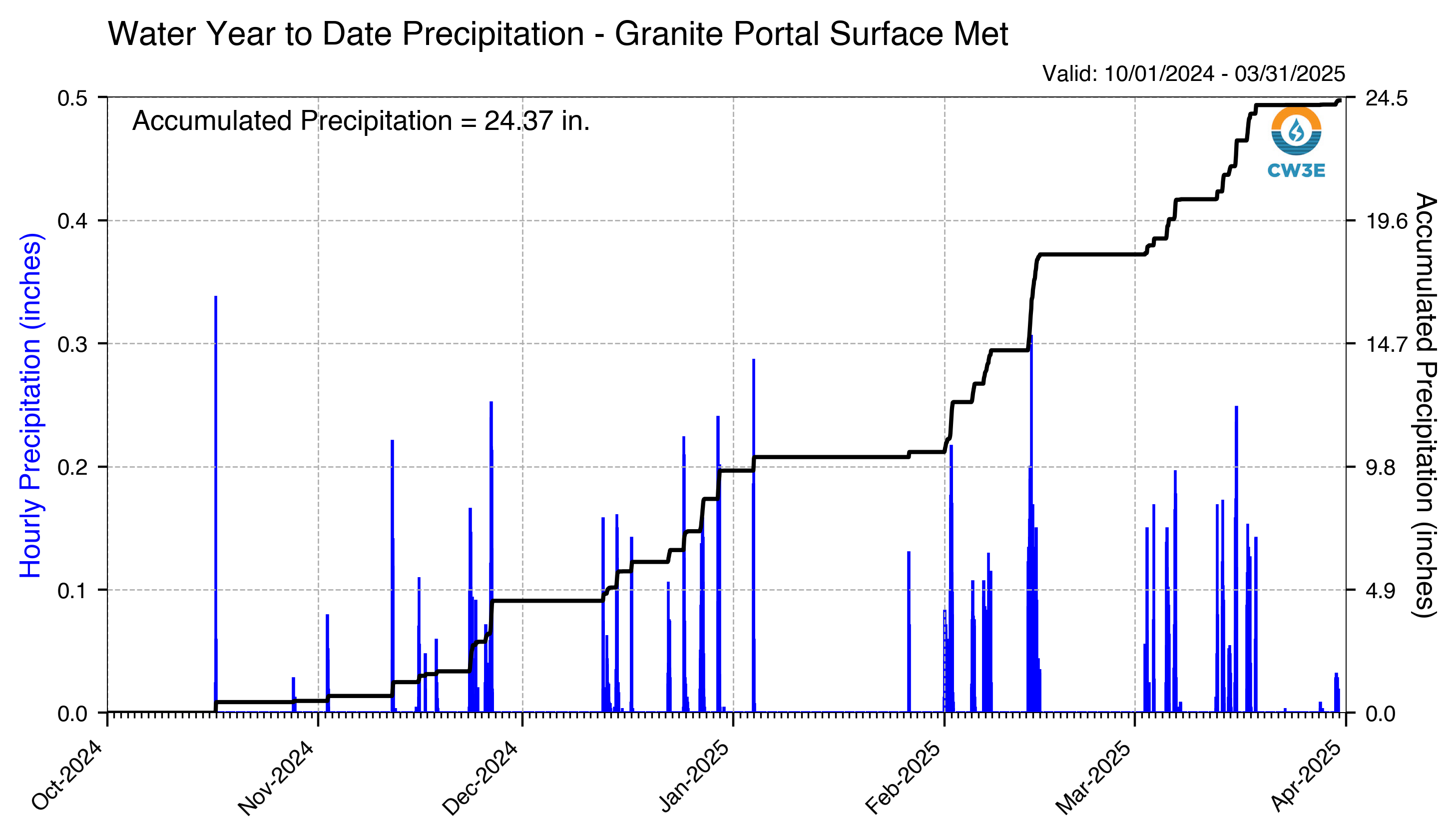
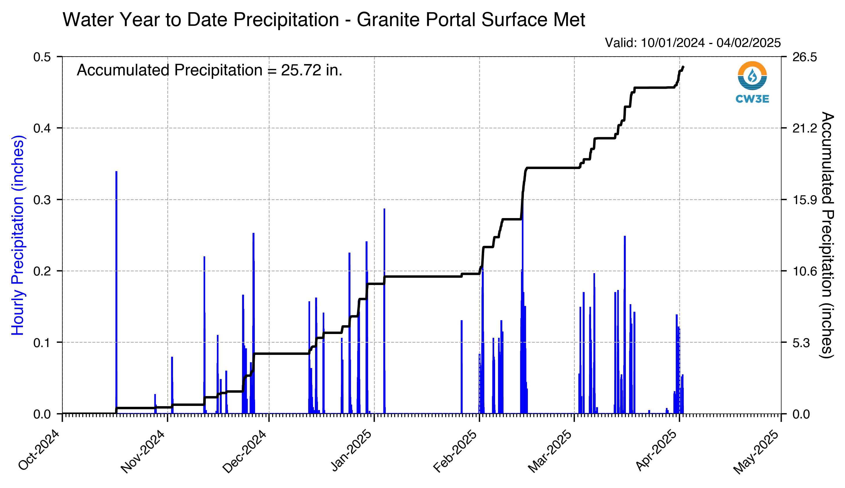
WYTD_Hourly_Precip_GPO_2025033000.png
2025-03-29 18:30
287K
WYTD_Hourly_Precip_GPO_2025032700.png
2025-03-26 18:31
288K
WYTD_Hourly_Precip_GPO_2025033100.png
2025-03-30 18:30
288K
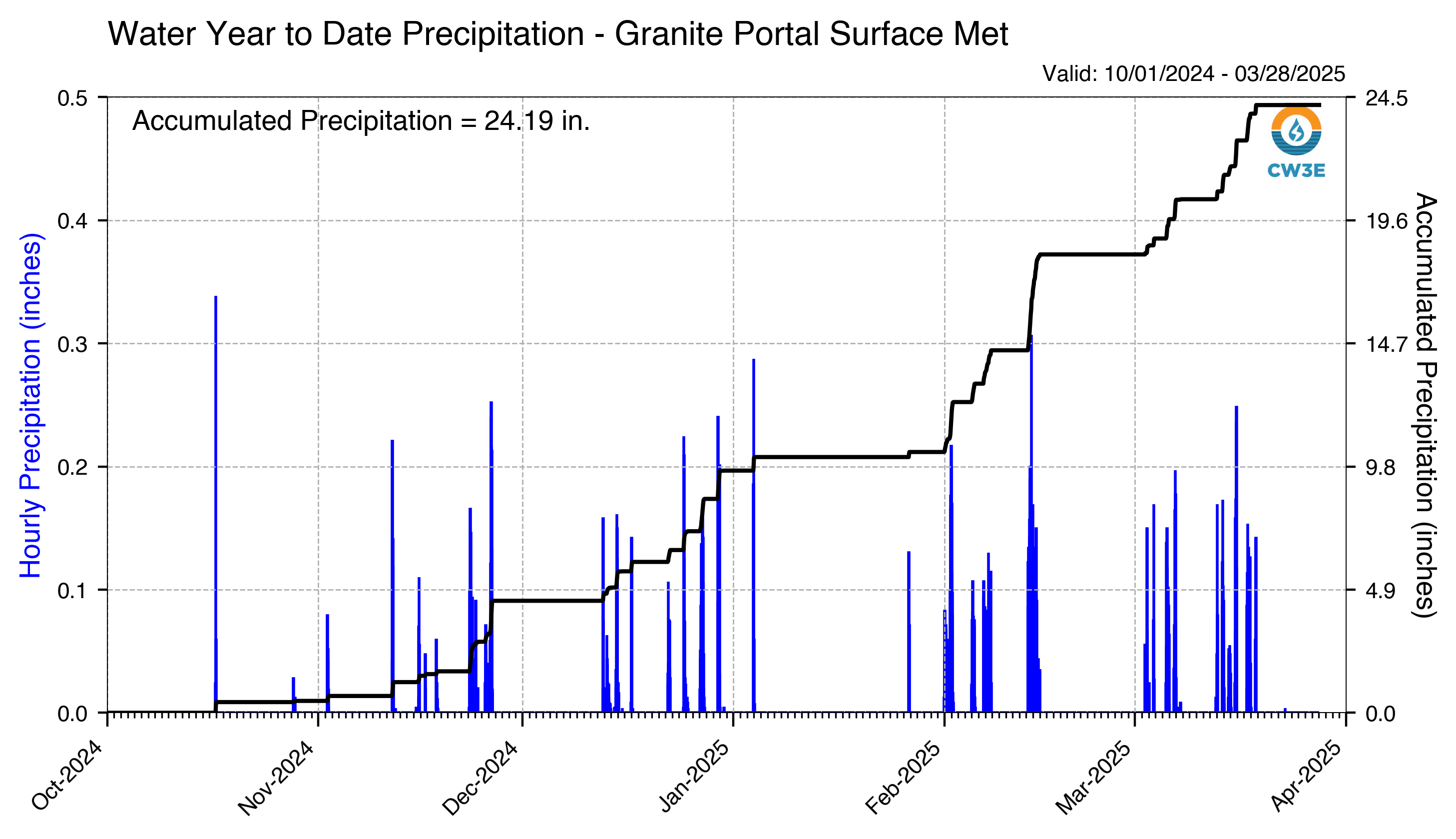
WYTD_Hourly_Precip_GPO_2025032900.png
2025-03-28 18:31
288K
WYTD_Hourly_Precip_GPO_2025032500.png
2025-03-24 18:30
289K
WYTD_Hourly_Precip_GPO_2025032800.png
2025-03-27 18:31
289K
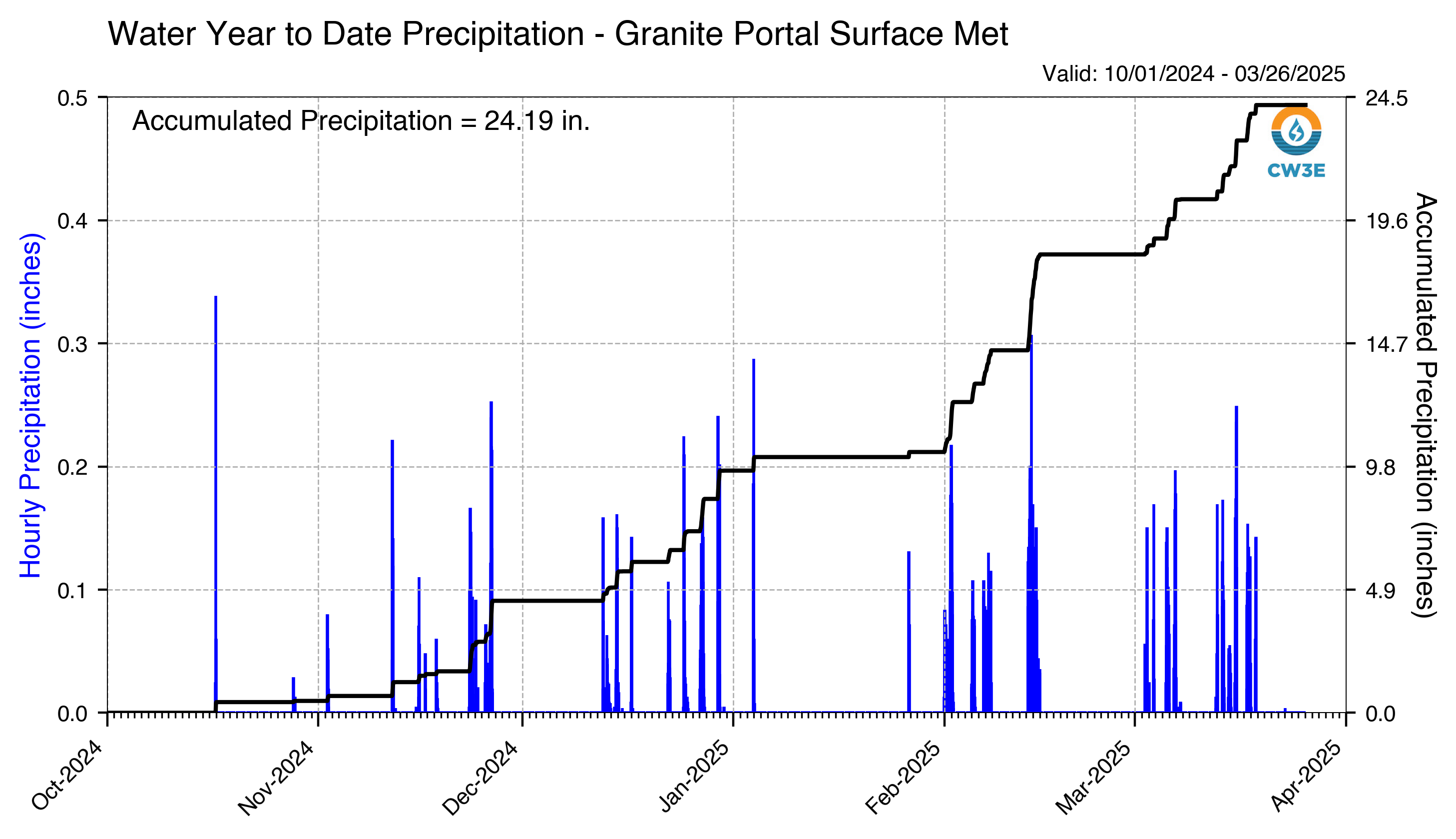
WYTD_Hourly_Precip_GPO_2025032600.png
2025-03-25 18:32
289K
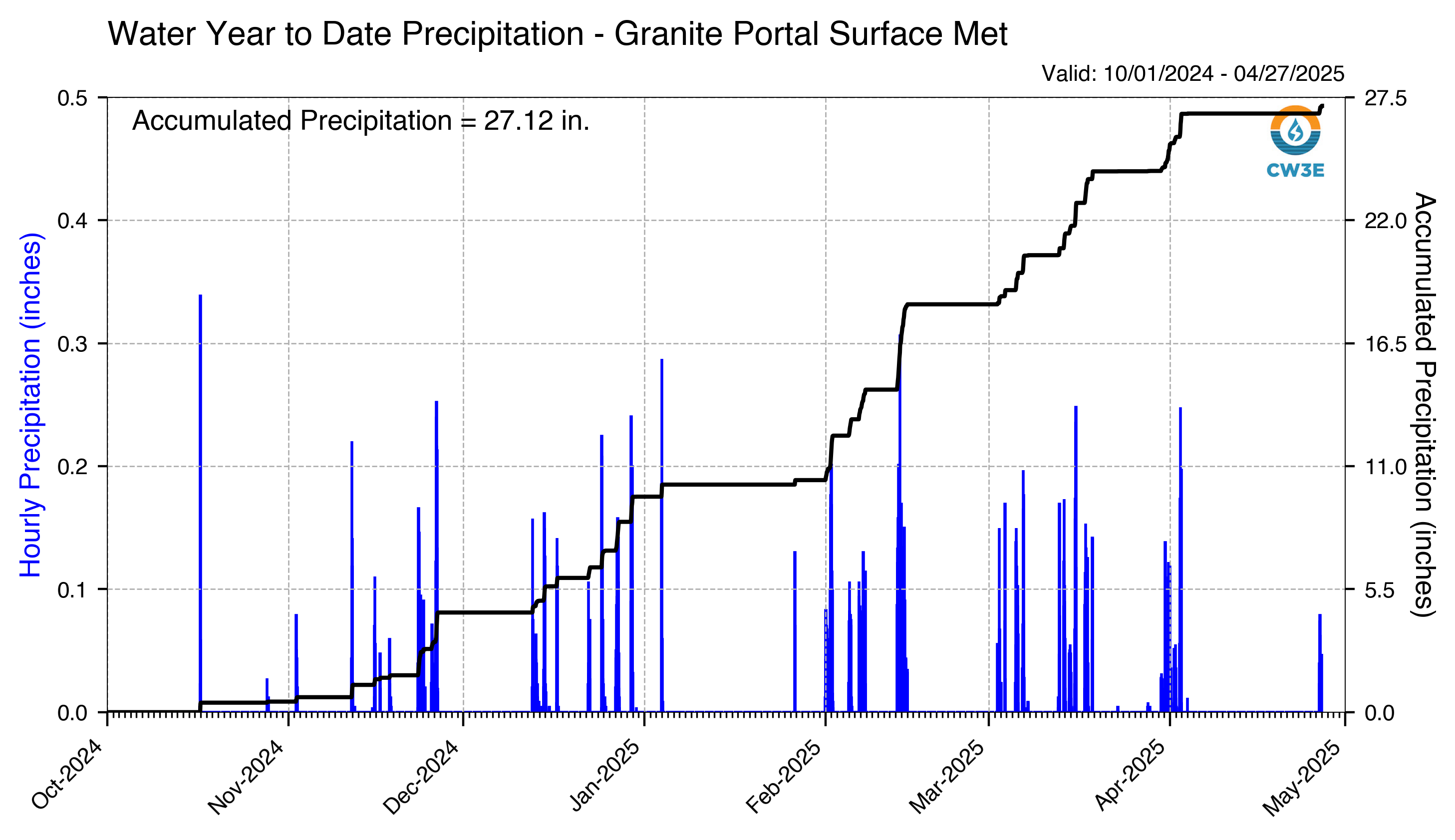
WYTD_Hourly_Precip_GPO_2025042700.png
2025-04-26 18:29
295K
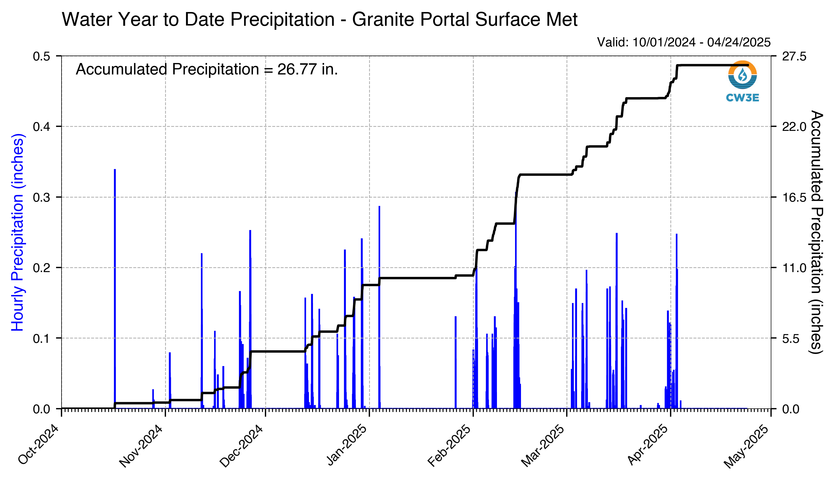
WYTD_Hourly_Precip_GPO_2025042400.png
2025-04-23 18:32
296K
WYTD_Hourly_Precip_GPO_2025042600.png
2025-04-25 18:29
296K
WYTD_Hourly_Precip_GPO_2025042500.png
2025-04-24 18:30
296K
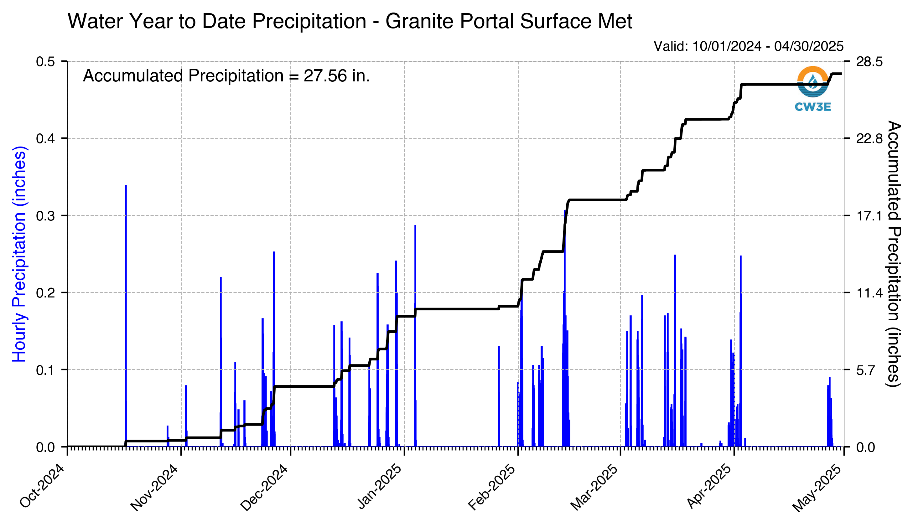
WYTD_Hourly_Precip_GPO_2025043000.png
2025-04-29 18:29
297K
WYTD_Hourly_Precip_GPO_2025042900.png
2025-04-28 18:30
297K
WYTD_Hourly_Precip_GPO_2025042800.png
2025-04-27 18:29
297K
WYTD_Hourly_Precip_GPO_2025042100.png
2025-04-20 18:30
297K
WYTD_Hourly_Precip_GPO_2025040100.png
2025-03-31 18:31
297K
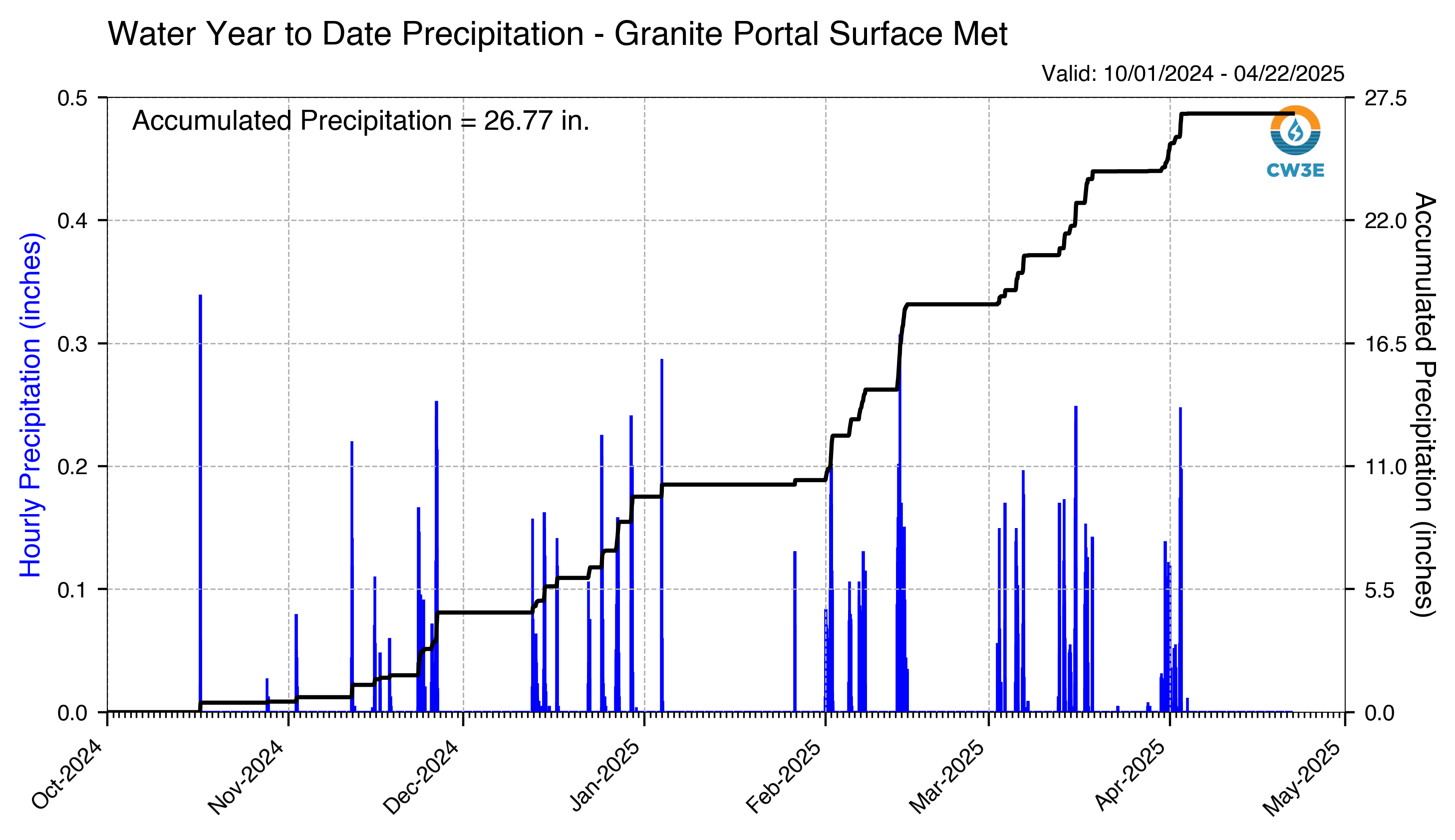
WYTD_Hourly_Precip_GPO_2025042300.png
2025-04-22 18:33
297K
WYTD_Hourly_Precip_GPO_2025042200.png
2025-04-21 18:32
297K
WYTD_Hourly_Precip_GPO_2025041100.png
2025-04-10 18:28
297K
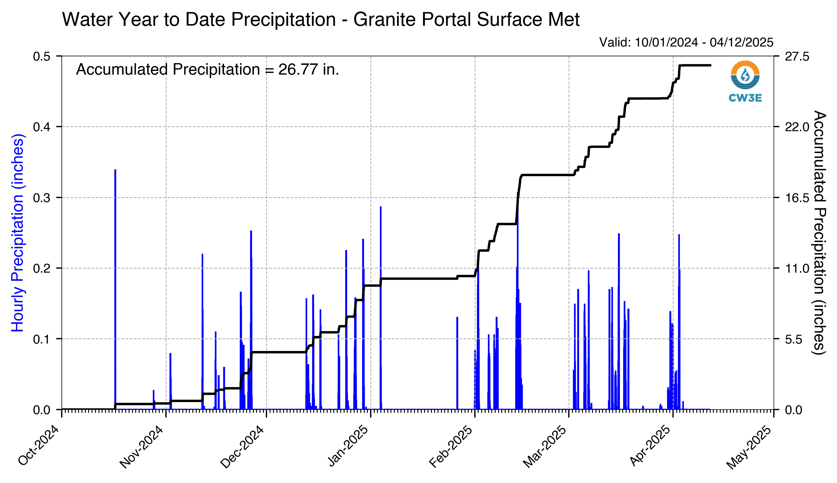
WYTD_Hourly_Precip_GPO_2025041400.png
2025-04-13 18:29
297K
WYTD_Hourly_Precip_GPO_2025042000.png
2025-04-19 18:29
298K
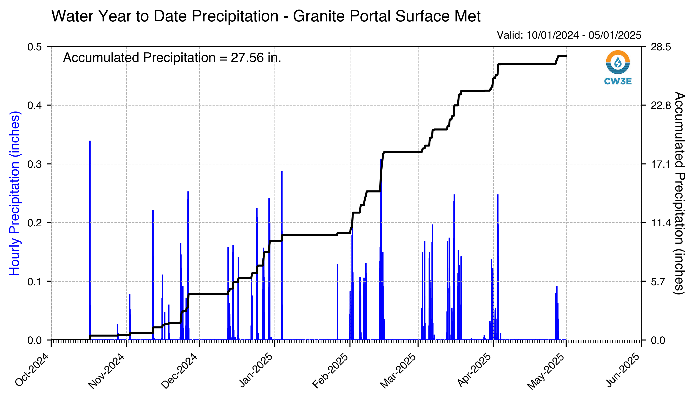
WYTD_Hourly_Precip_GPO_2025050100.png
2025-04-30 18:33
298K
WYTD_Hourly_Precip_GPO_2025041700.png
2025-04-16 18:29
298K
WYTD_Hourly_Precip_GPO_2025041200.png
2025-04-11 18:28
298K
WYTD_Hourly_Precip_GPO_2025041000.png
2025-04-09 18:28
298K
WYTD_Hourly_Precip_GPO_2025050700.png
2025-05-06 18:33
298K
WYTD_Hourly_Precip_GPO_2025041500.png
2025-04-14 18:29
298K
WYTD_Hourly_Precip_GPO_2025040400.png
2025-04-03 18:28
298K
WYTD_Hourly_Precip_GPO_2025041900.png
2025-04-18 18:28
298K
WYTD_Hourly_Precip_GPO_2025041300.png
2025-04-12 18:28
298K
WYTD_Hourly_Precip_GPO_2025050500.png
2025-05-04 18:30
298K
WYTD_Hourly_Precip_GPO_2025040700.png
2025-04-06 18:29
298K
WYTD_Hourly_Precip_GPO_2025041600.png
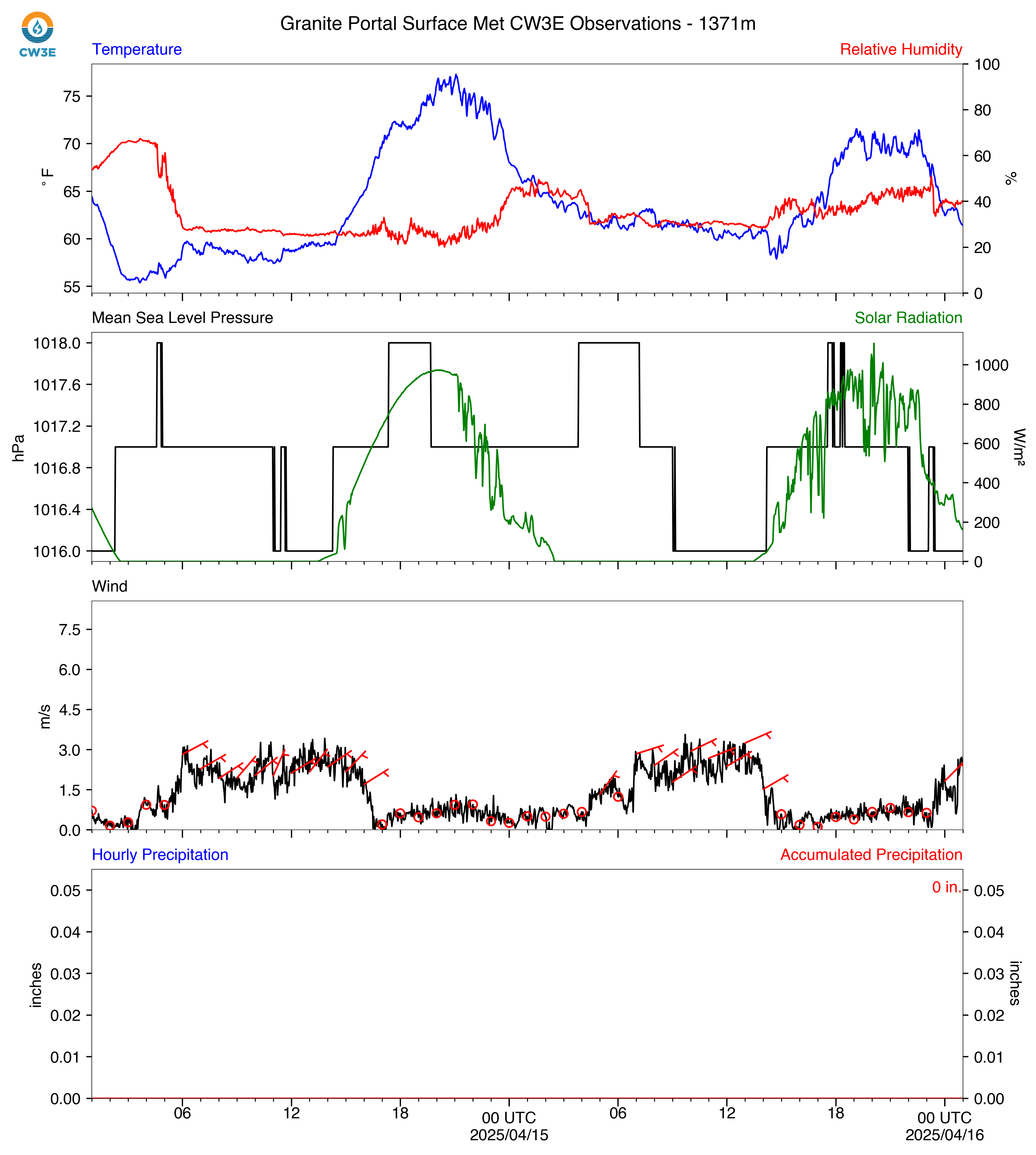
2025-04-15 18:29
298K
WYTD_Hourly_Precip_GPO_2025041800.png
2025-04-17 18:29
298K
WYTD_Hourly_Precip_GPO_2025050200.png
2025-05-01 18:32
298K
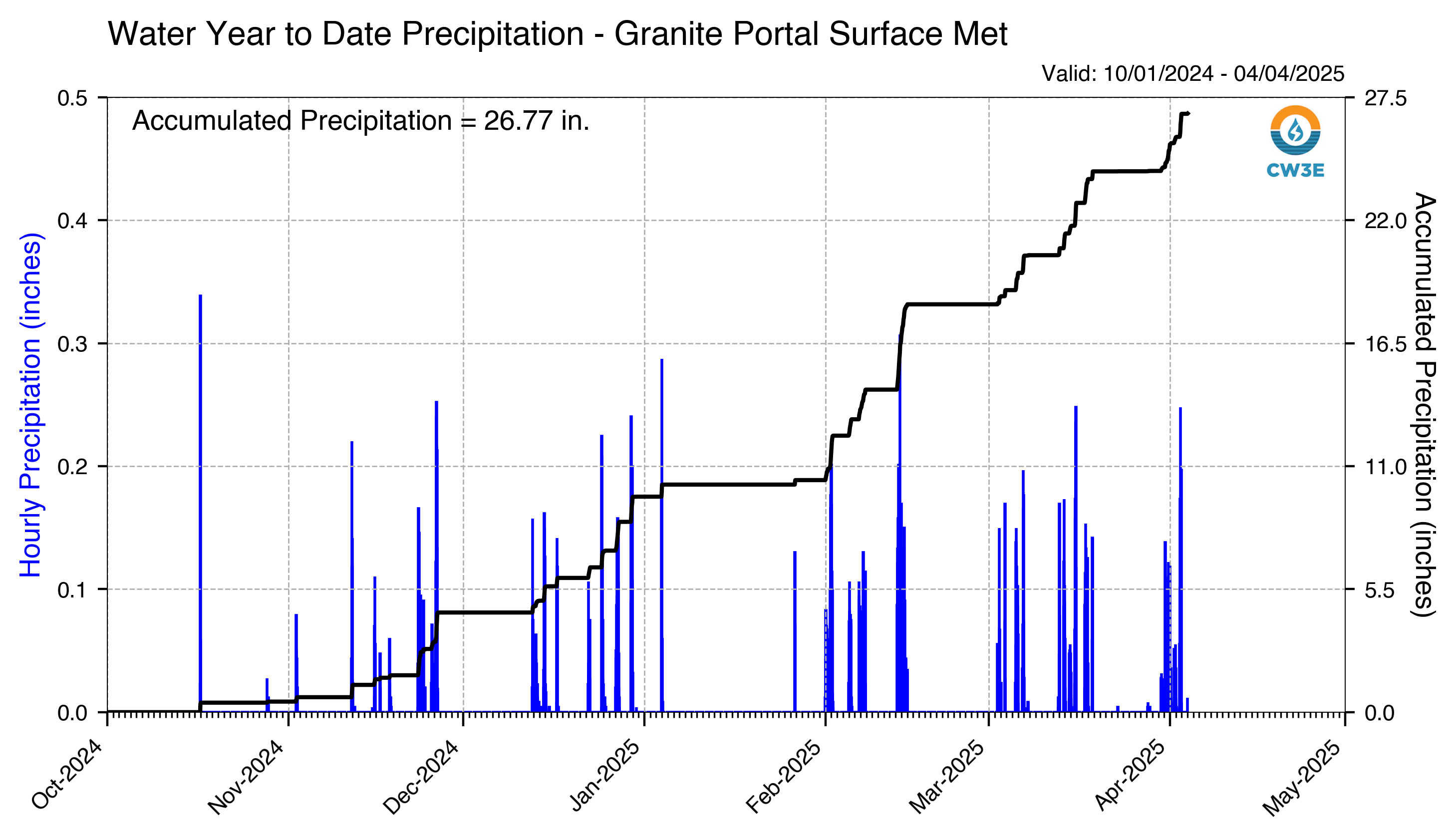
WYTD_Hourly_Precip_GPO_2025040500.png
2025-04-04 18:27
299K
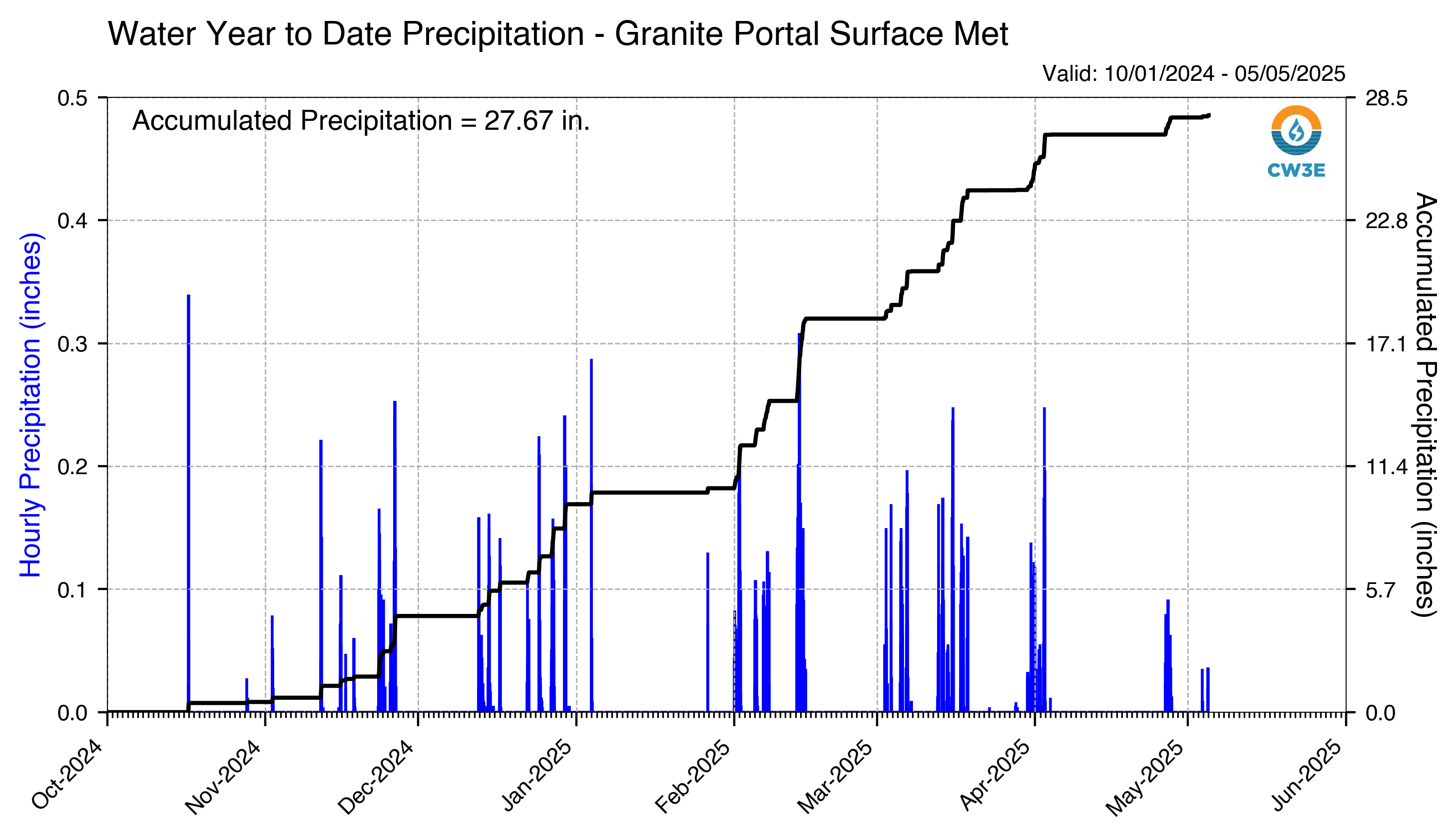
WYTD_Hourly_Precip_GPO_2025050600.png
2025-05-05 18:31
299K
WYTD_Hourly_Precip_GPO_2025050900.png
2025-05-08 18:32
299K
WYTD_Hourly_Precip_GPO_2025050300.png
2025-05-02 18:31
299K
WYTD_Hourly_Precip_GPO_2025050800.png
2025-05-07 18:42
299K
WYTD_Hourly_Precip_GPO_2025040900.png
2025-04-08 18:28
299K
WYTD_Hourly_Precip_GPO_2025040600.png
2025-04-05 18:28
299K
WYTD_Hourly_Precip_GPO_2025040800.png
2025-04-07 18:28
299K
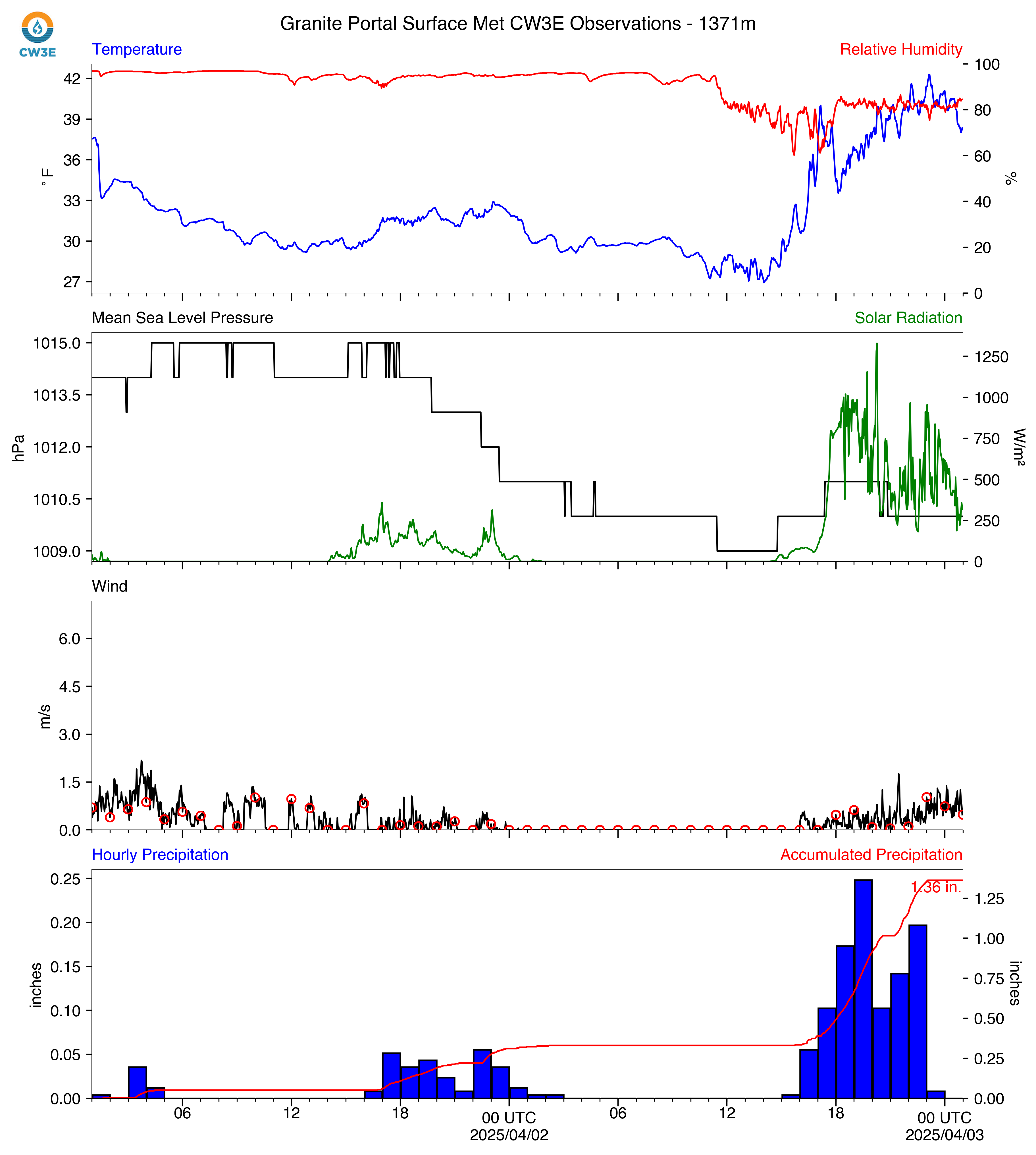
WYTD_Hourly_Precip_GPO_2025040300.png
2025-04-02 18:28
300K
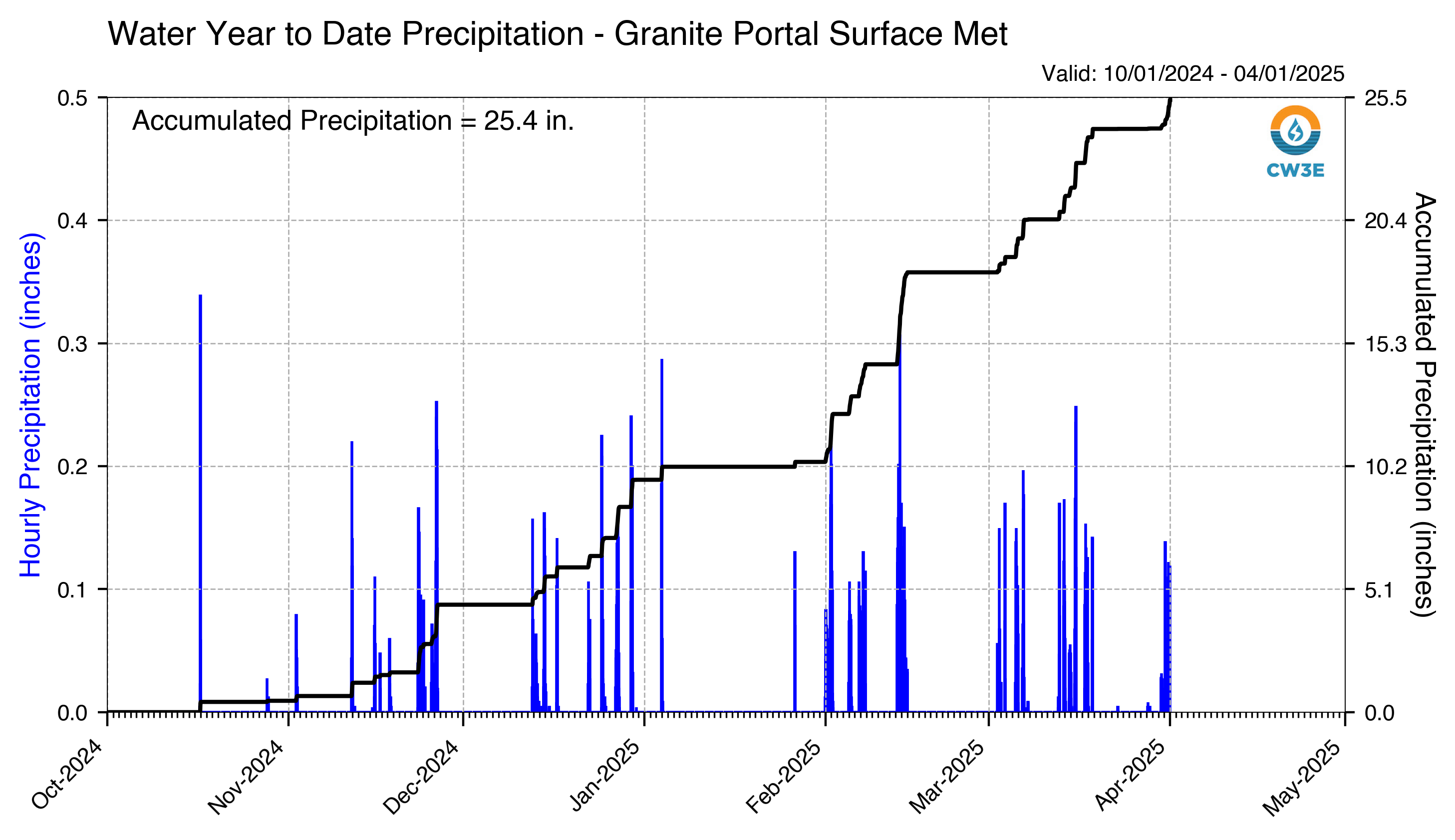
WYTD_Hourly_Precip_GPO_2025040200.png
2025-04-01 18:30
300K
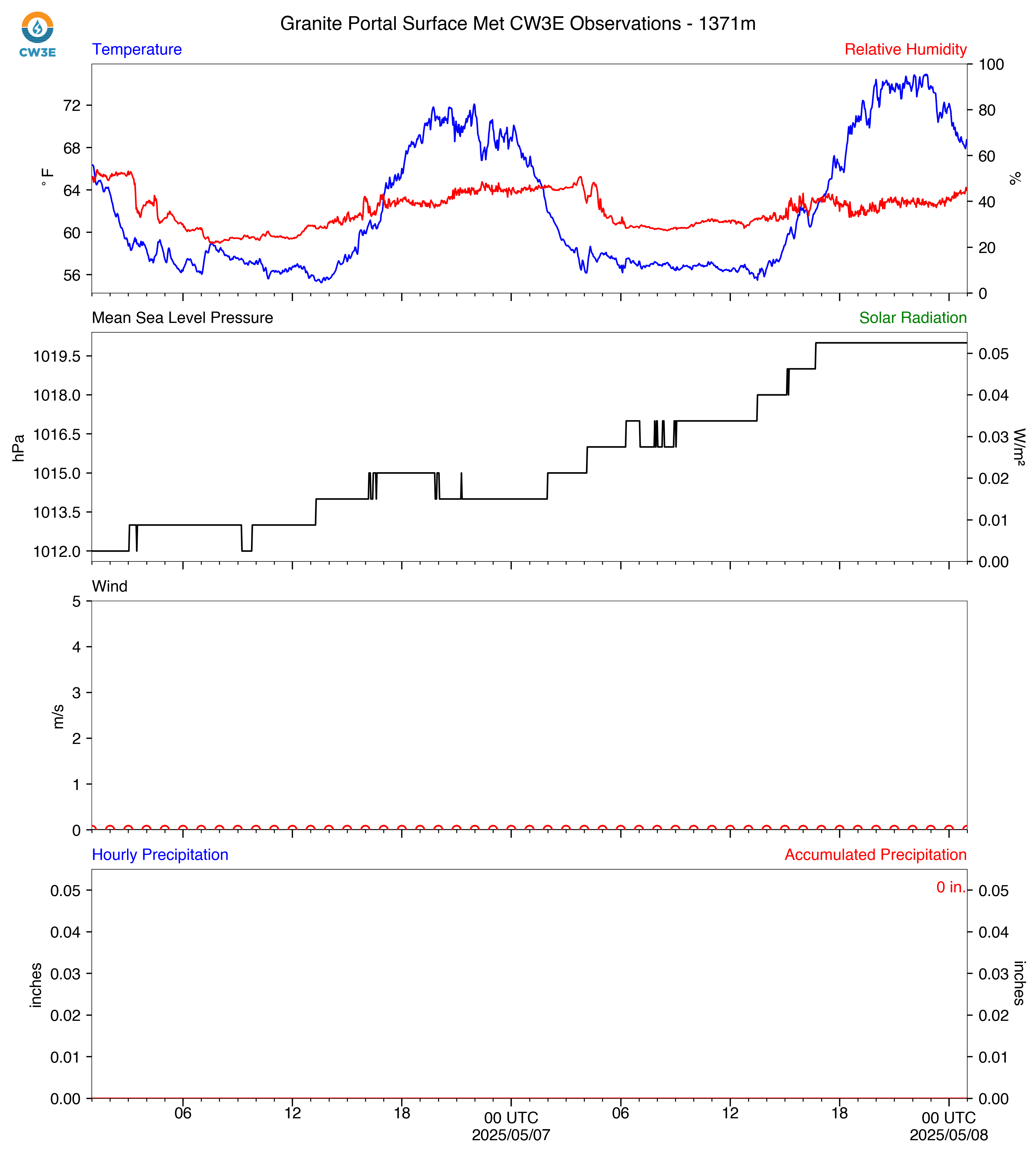
GPO_2025050900_SurfaceMet.png
2025-05-08 18:32
504K
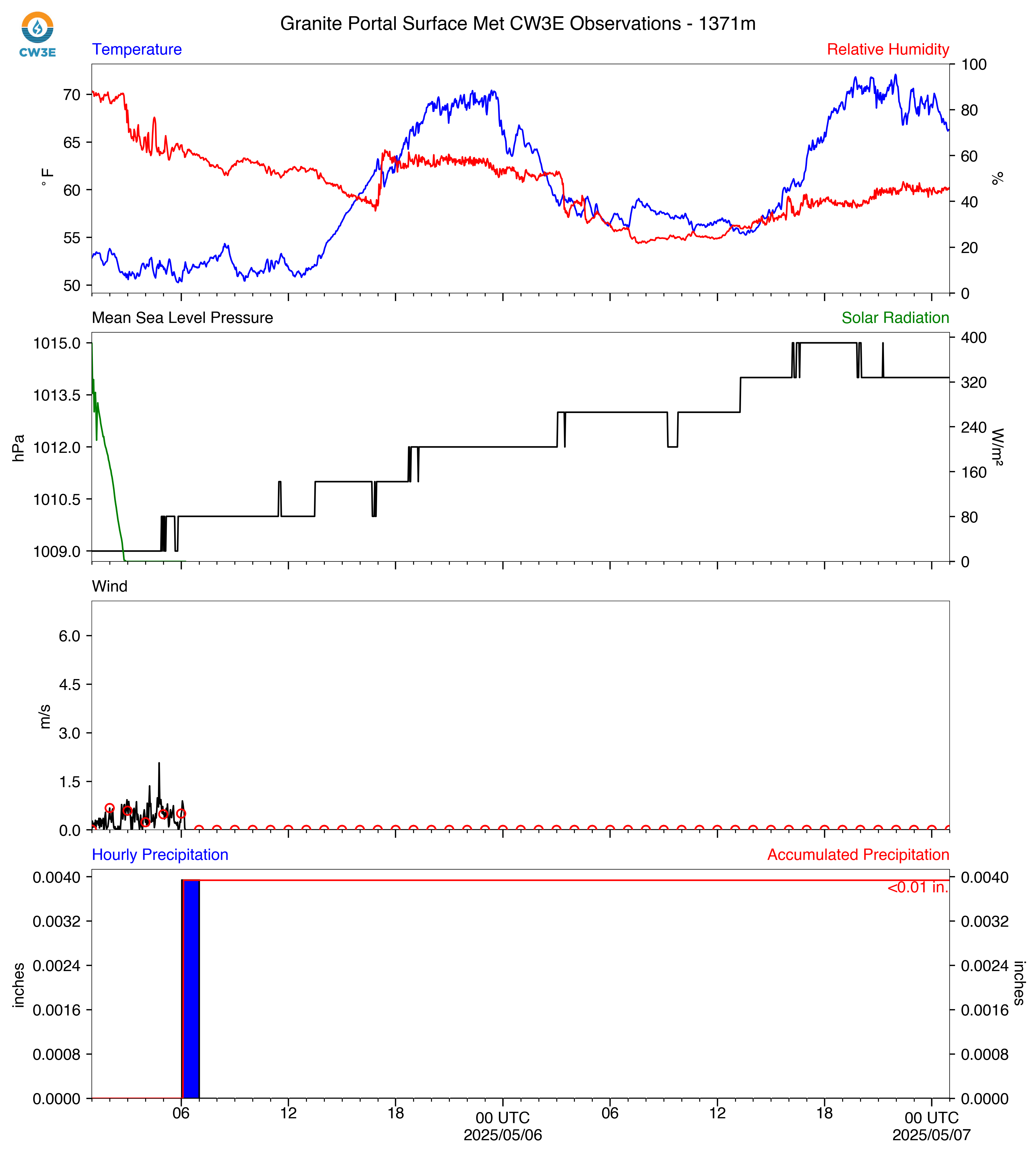
GPO_2025050800_SurfaceMet.png
2025-05-07 18:42
522K
GPO_2025050700_SurfaceMet.png
2025-05-06 18:33
572K
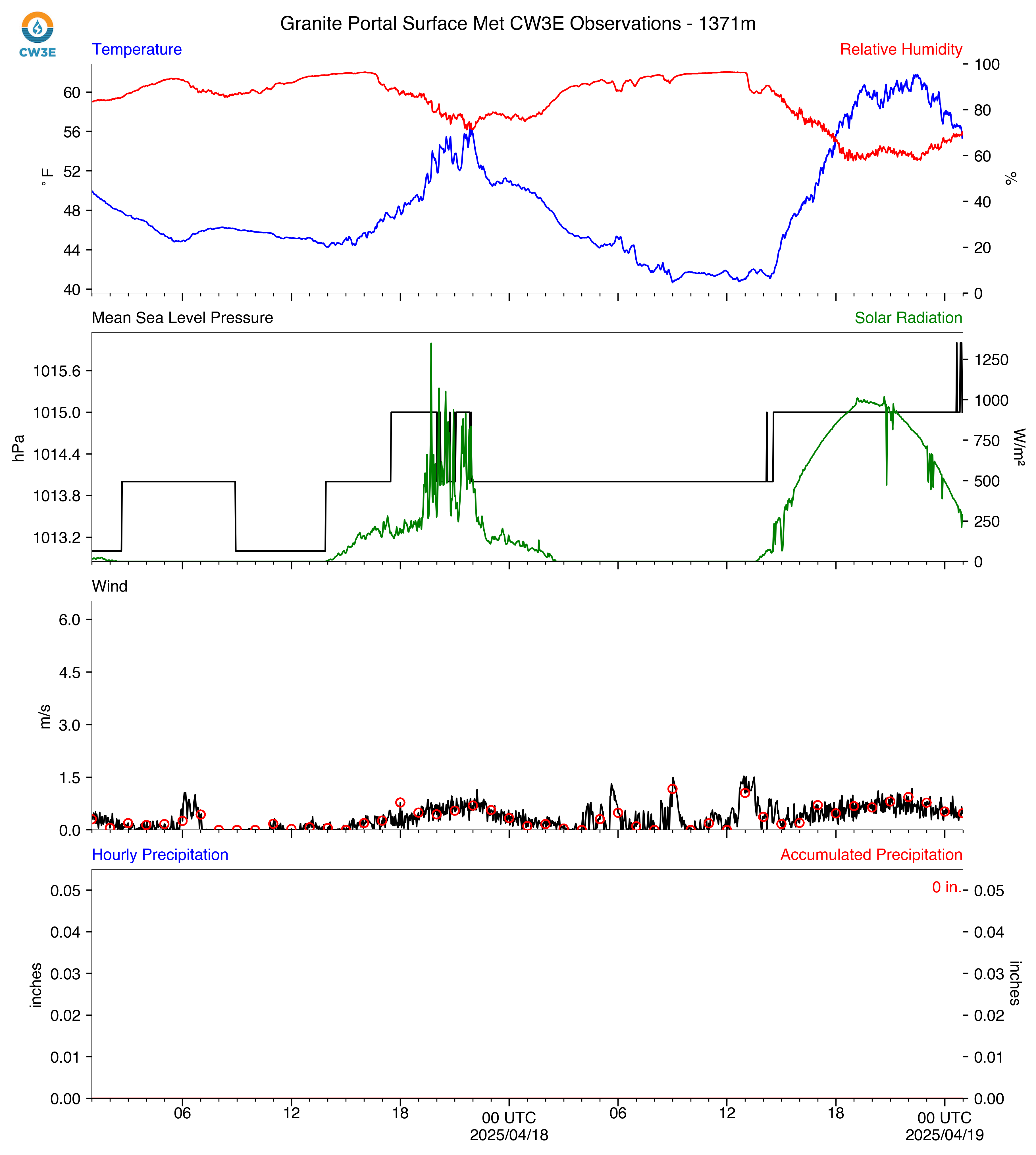
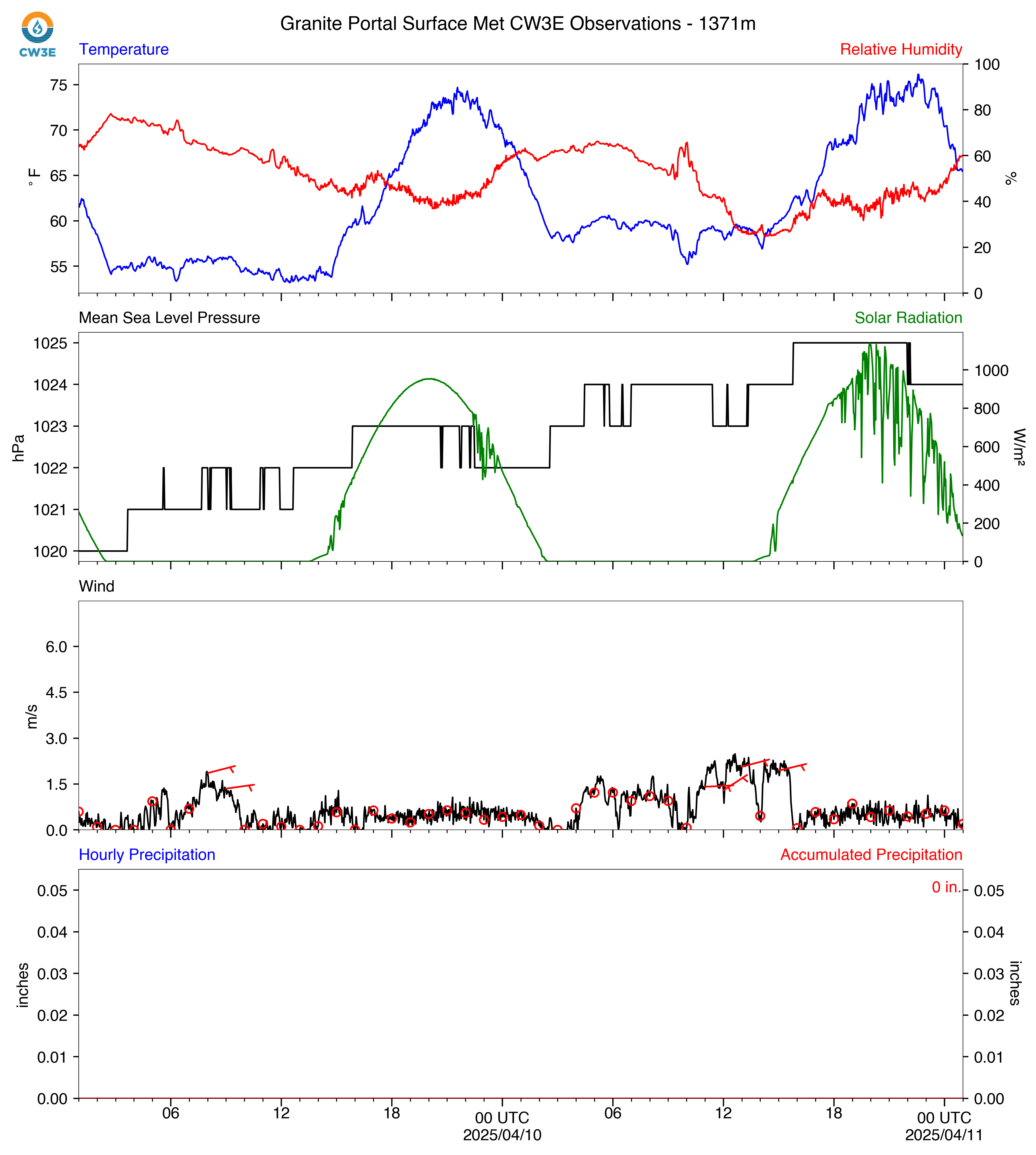
GPO_2025041900_SurfaceMet.png
2025-04-18 18:28
662K
GPO_2025030700_SurfaceMet.png
2025-03-06 17:26
665K
GPO_2025040300_SurfaceMet.png
2025-04-02 18:28
679K
GPO_2025041800_SurfaceMet.png
2025-04-17 18:29
682K
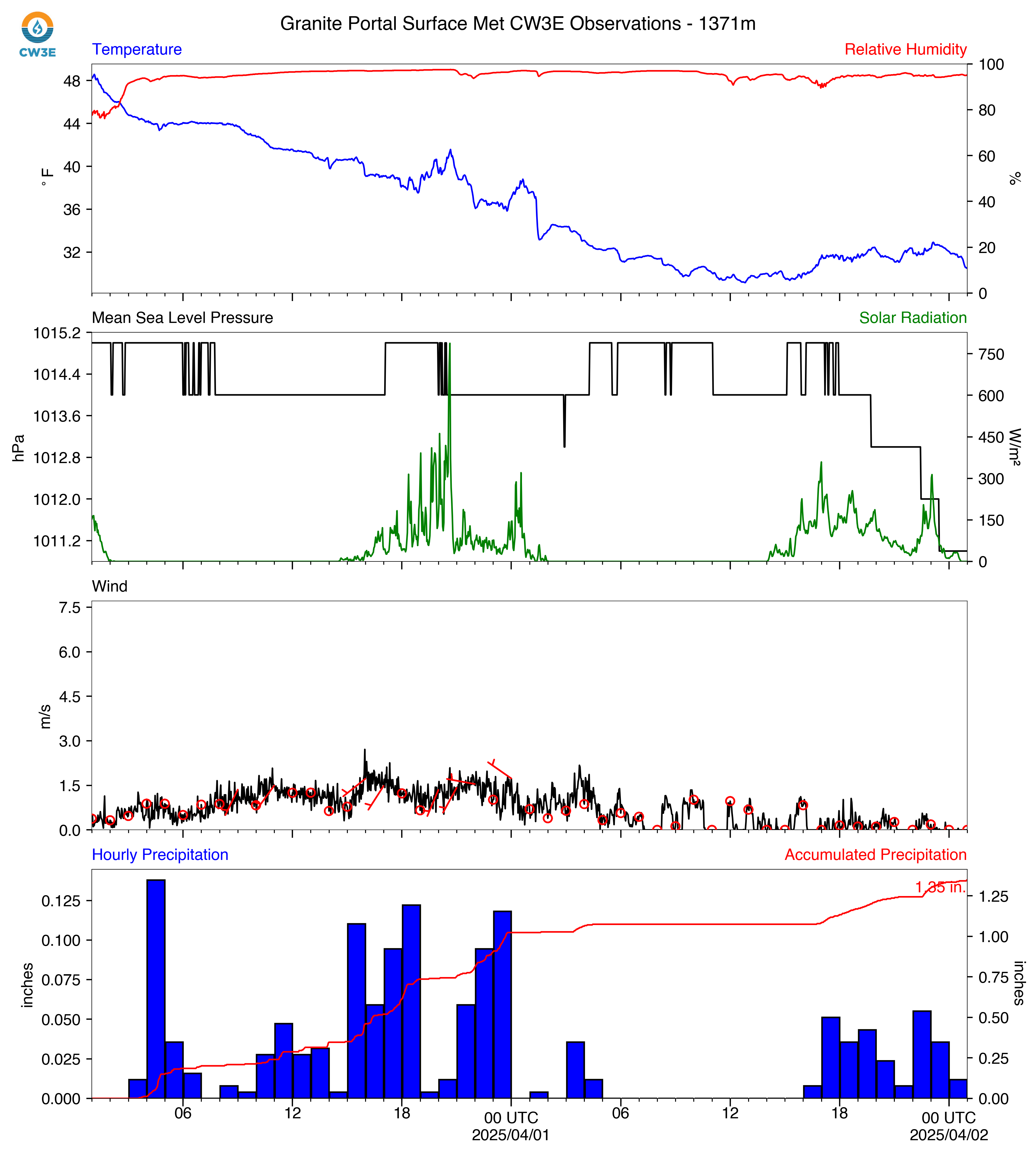
GPO_2025040200_SurfaceMet.png
2025-04-01 18:30
686K
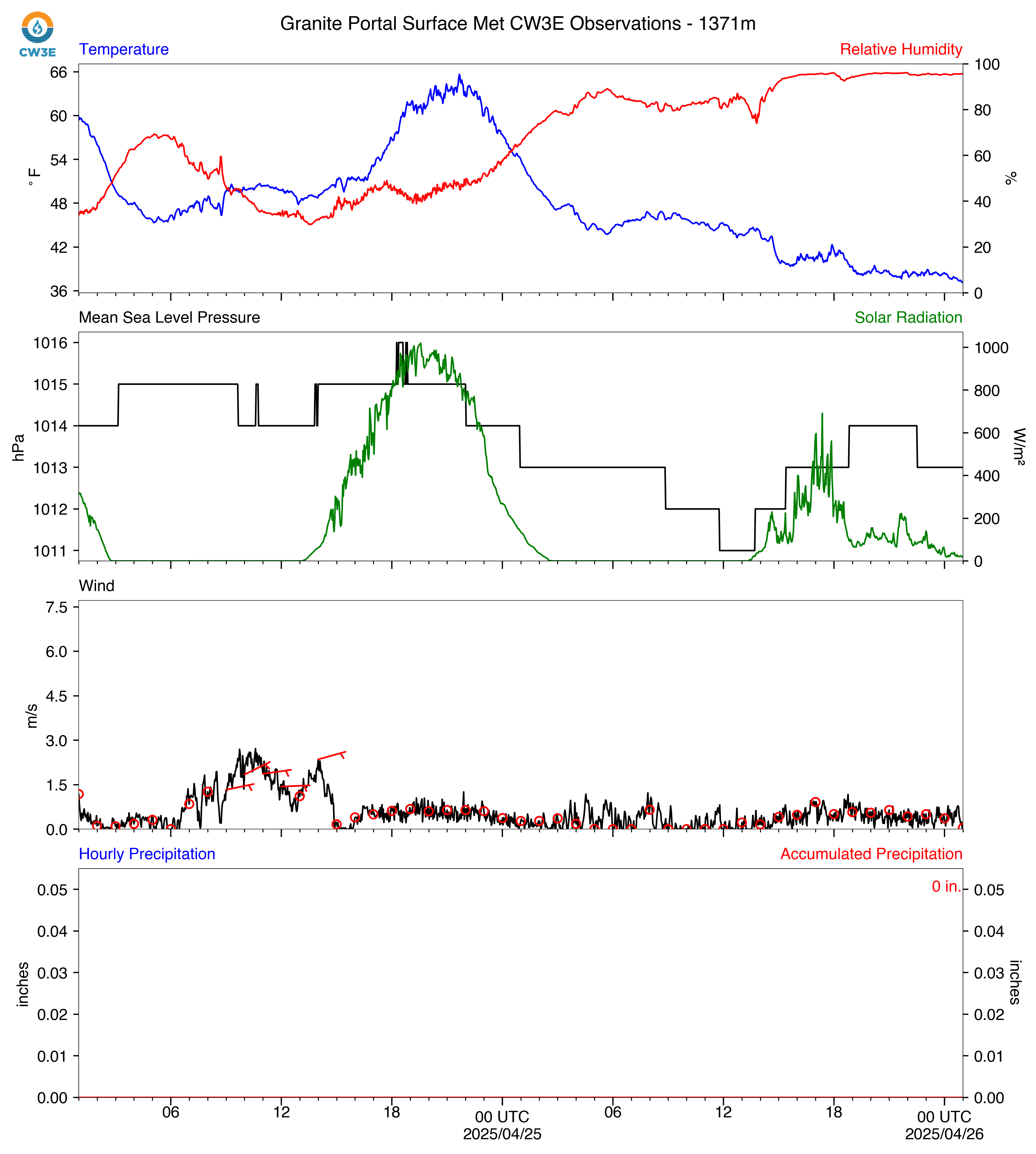
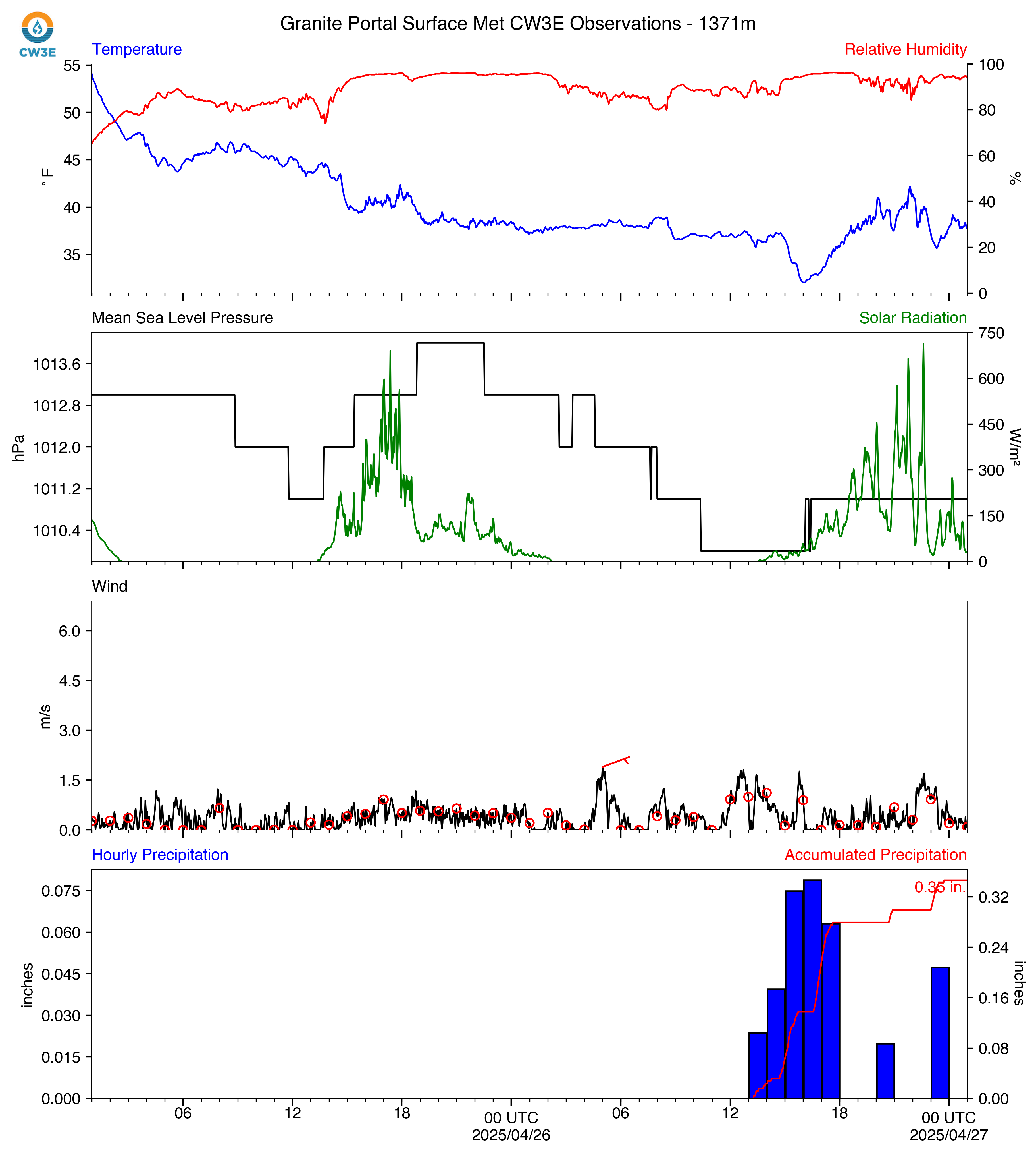
GPO_2025042600_SurfaceMet.png
2025-04-25 18:29
693K
GPO_2025050600_SurfaceMet.png
2025-05-05 18:31
694K
GPO_2025042200_SurfaceMet.png
2025-04-21 18:32
694K
GPO_2025042900_SurfaceMet.png
2025-04-28 18:30
696K
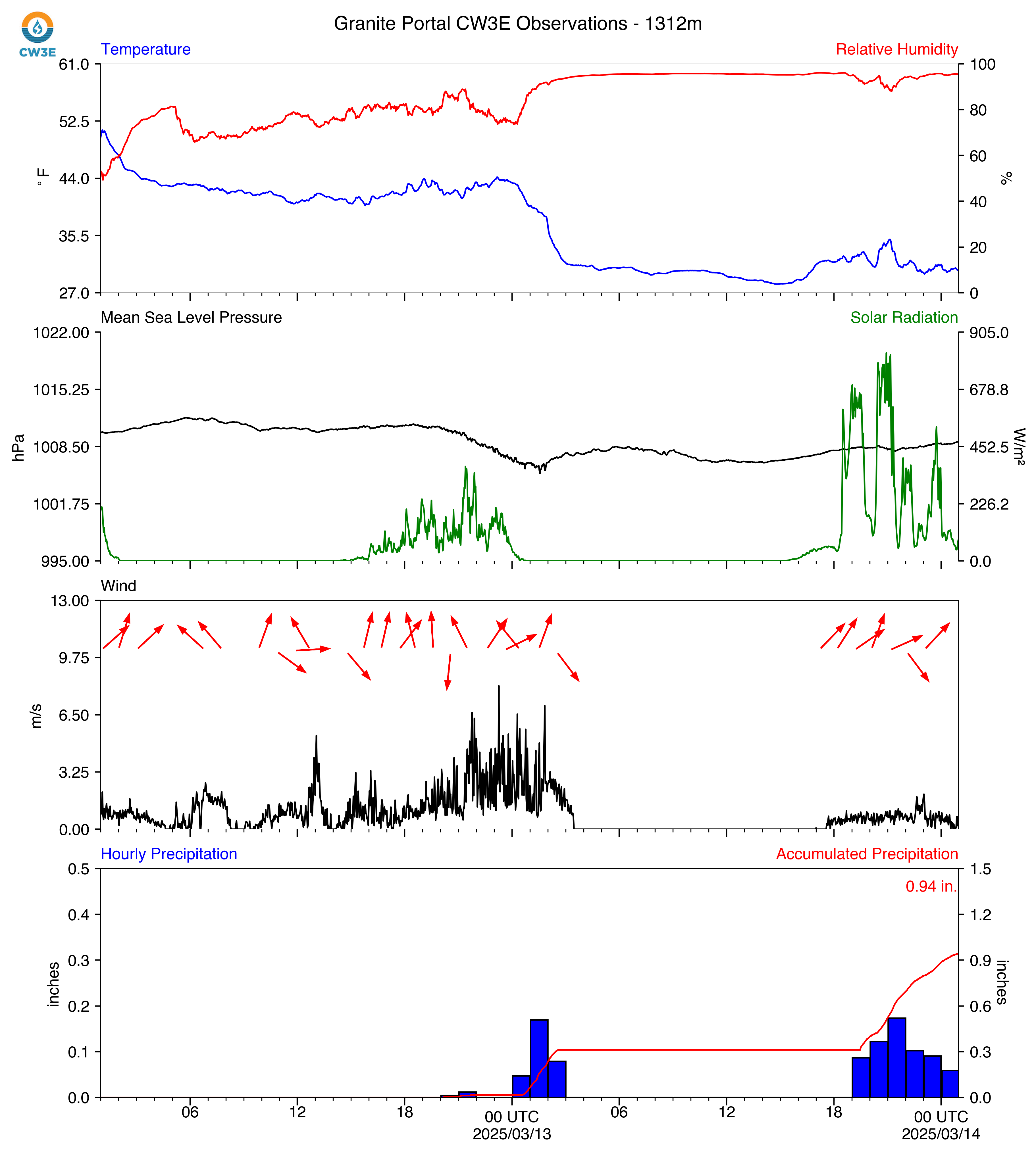
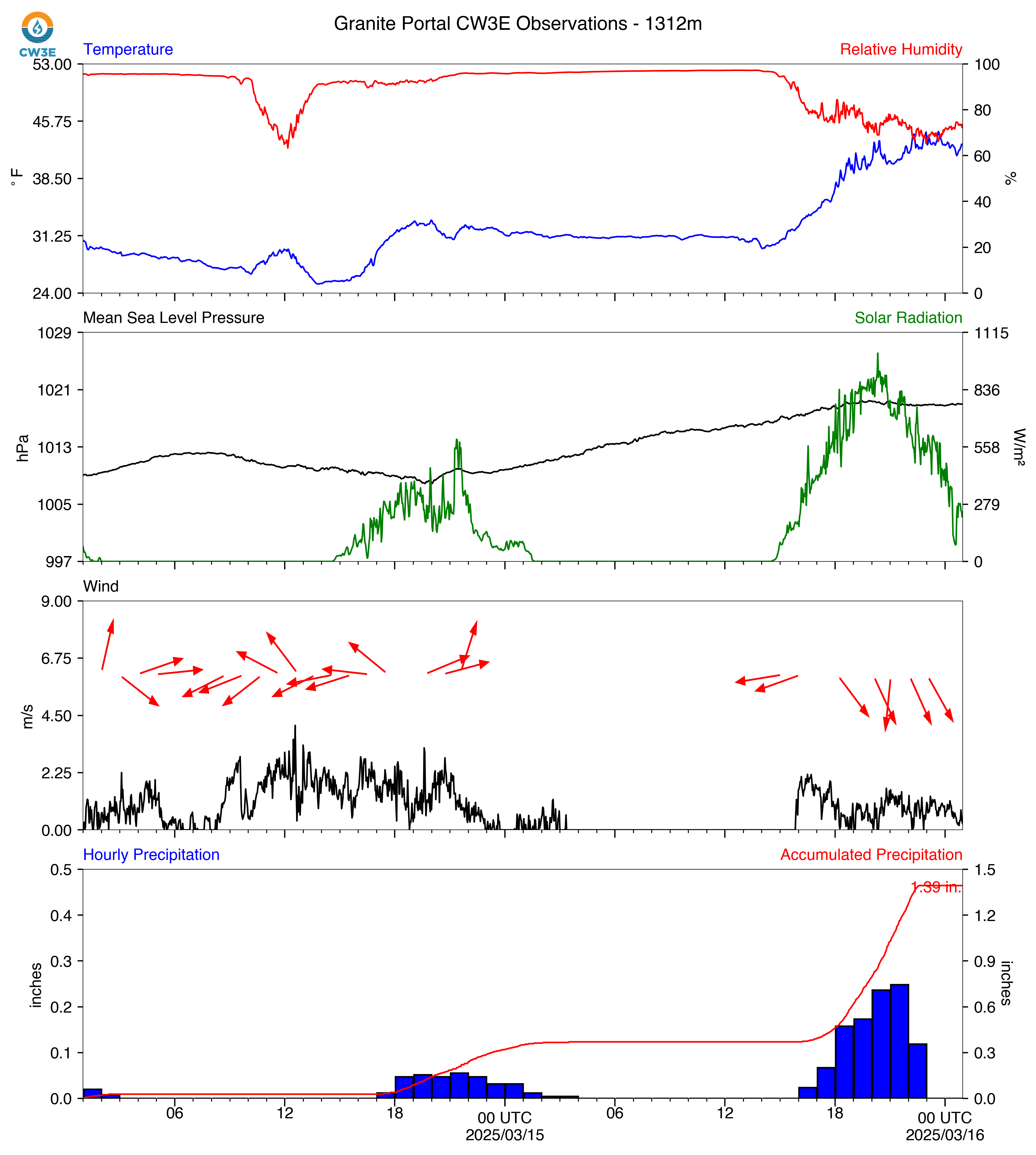
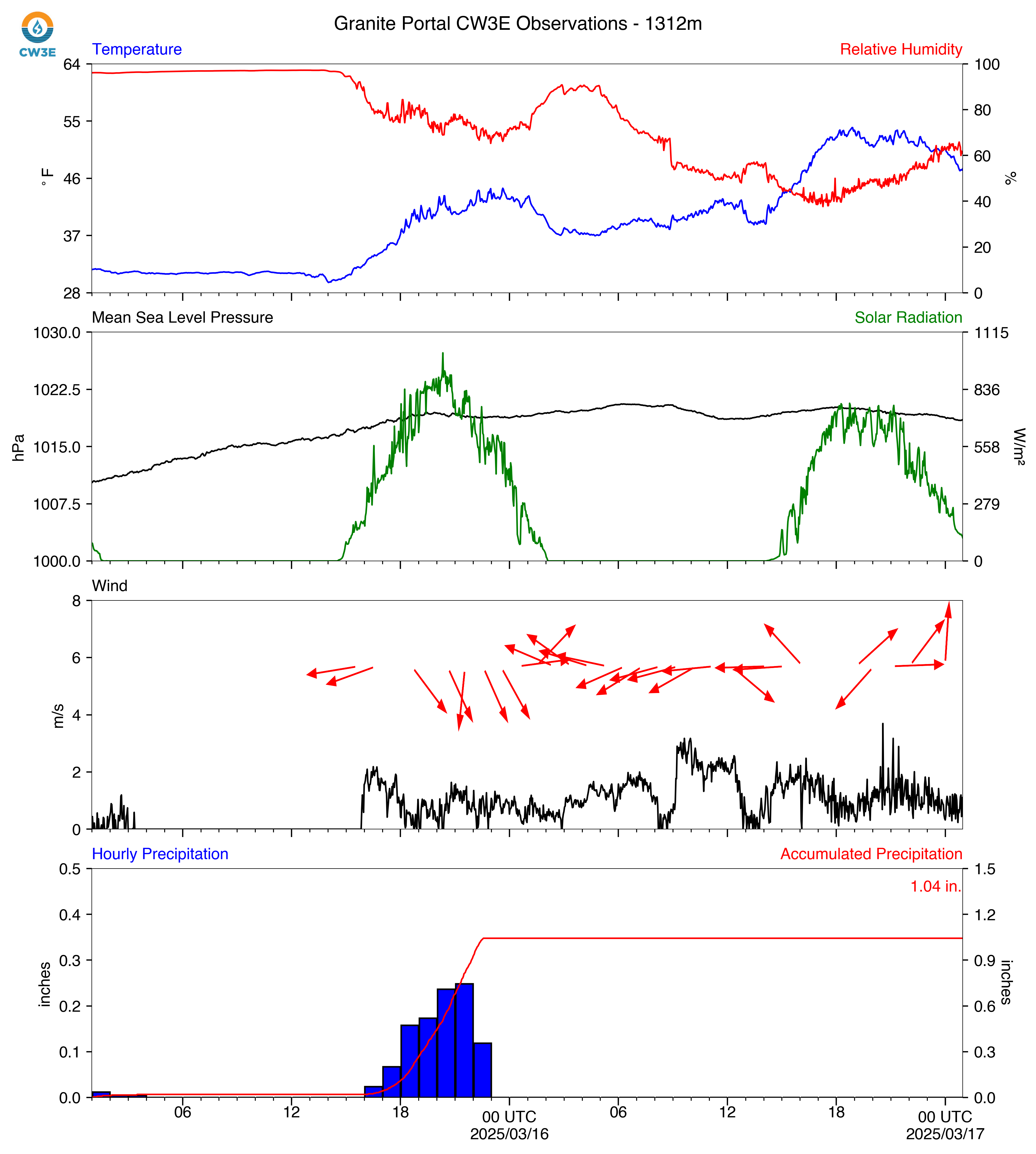
GPO_2025031500_SurfaceMet.png
2025-03-14 18:22
698K
GPO_2025041000_SurfaceMet.png
2025-04-09 18:28
700K
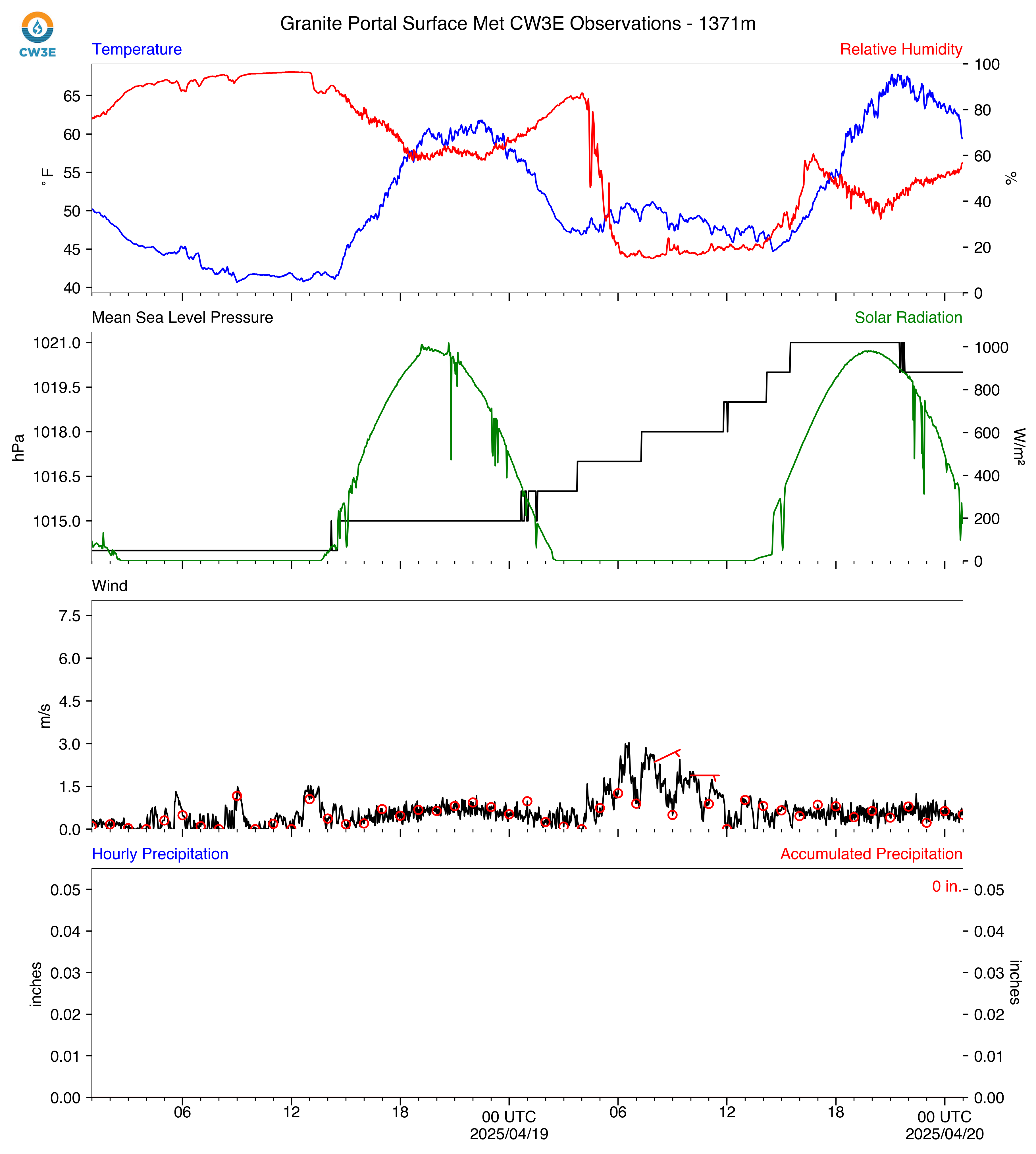
GPO_2025042000_SurfaceMet.png
2025-04-19 18:29
701K
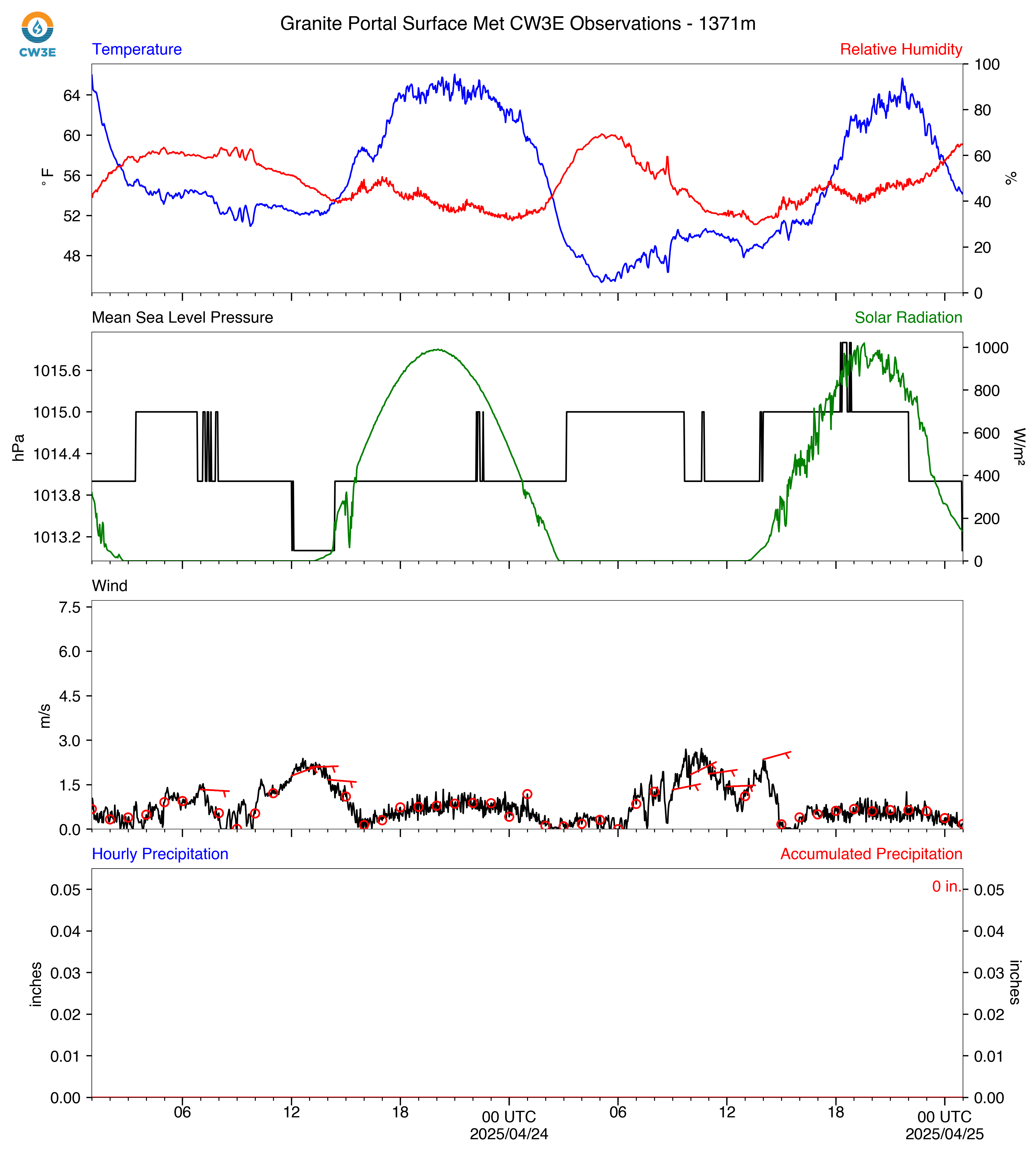
GPO_2025042400_SurfaceMet.png
2025-04-23 18:32
704K
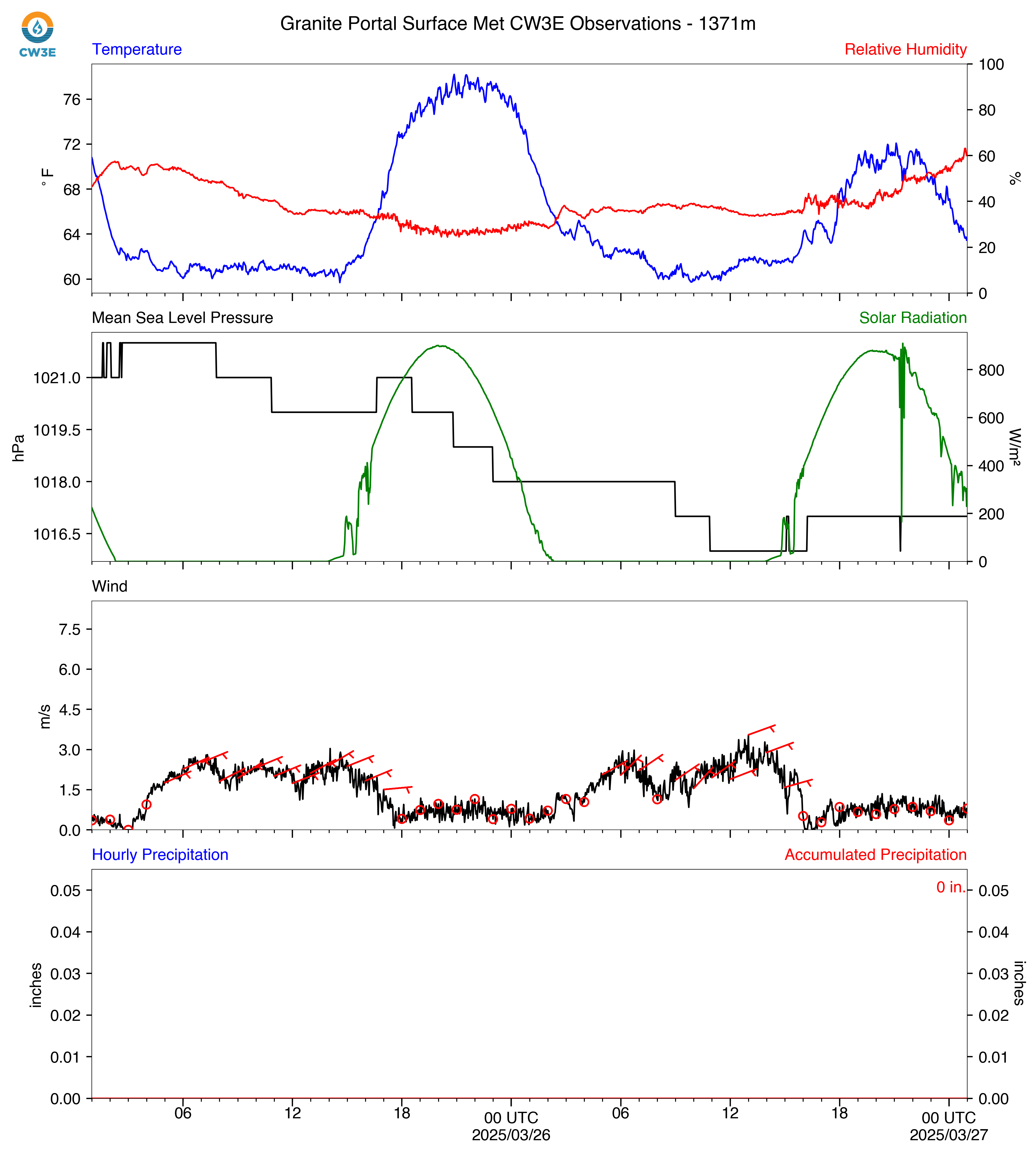
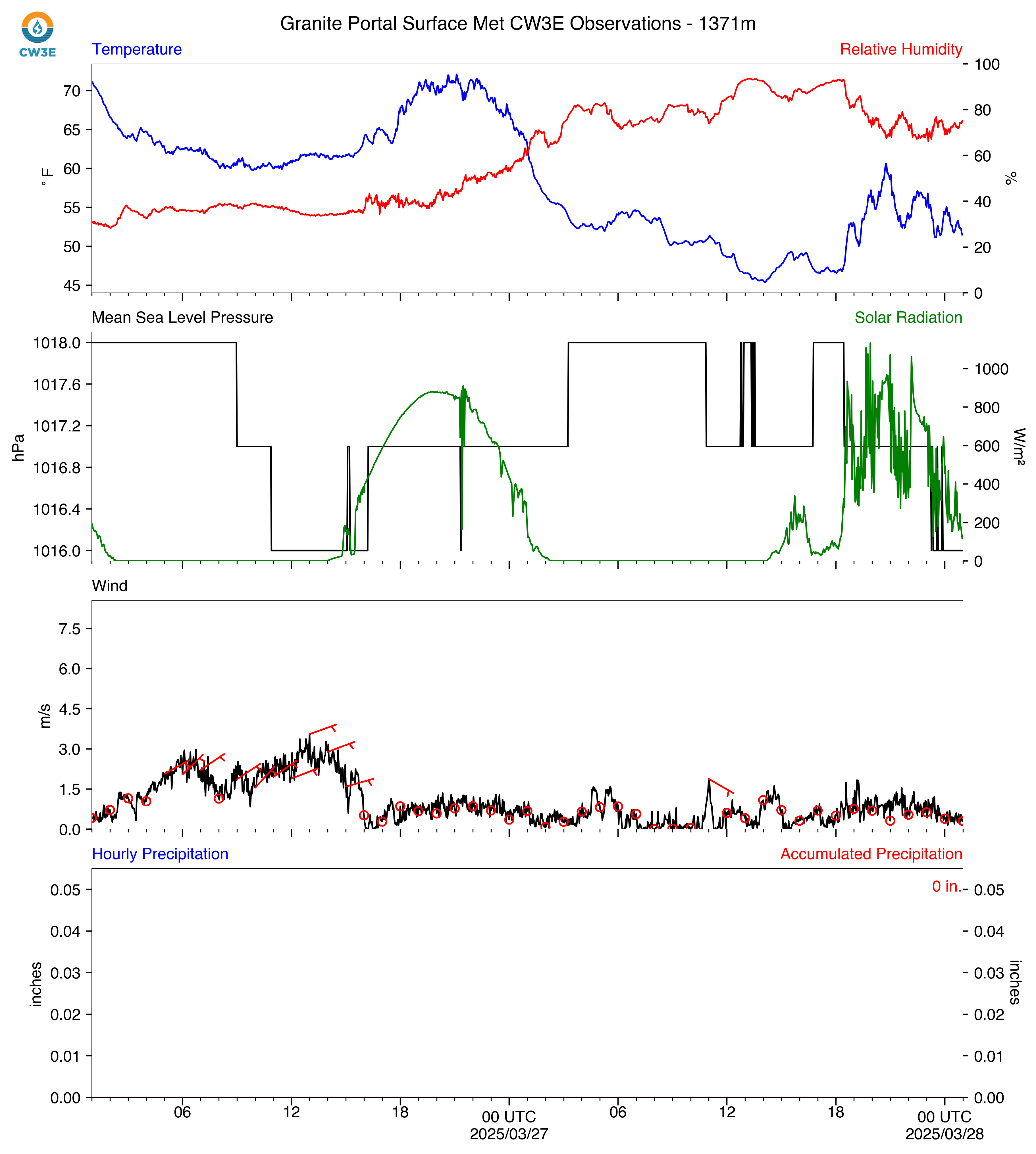
GPO_2025032700_SurfaceMet.png
2025-03-26 18:31
704K
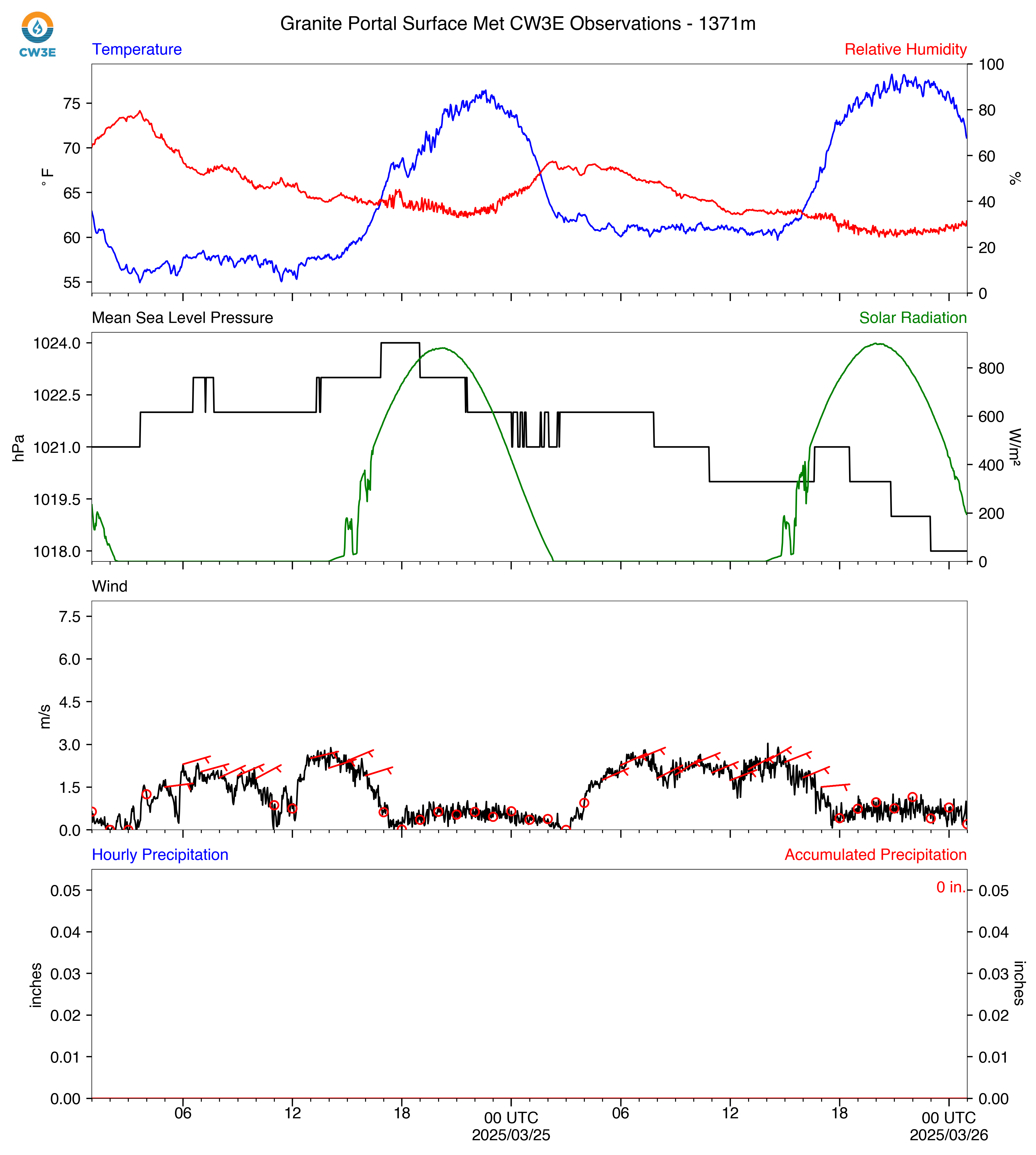
GPO_2025032600_SurfaceMet.png
2025-03-25 18:32
706K
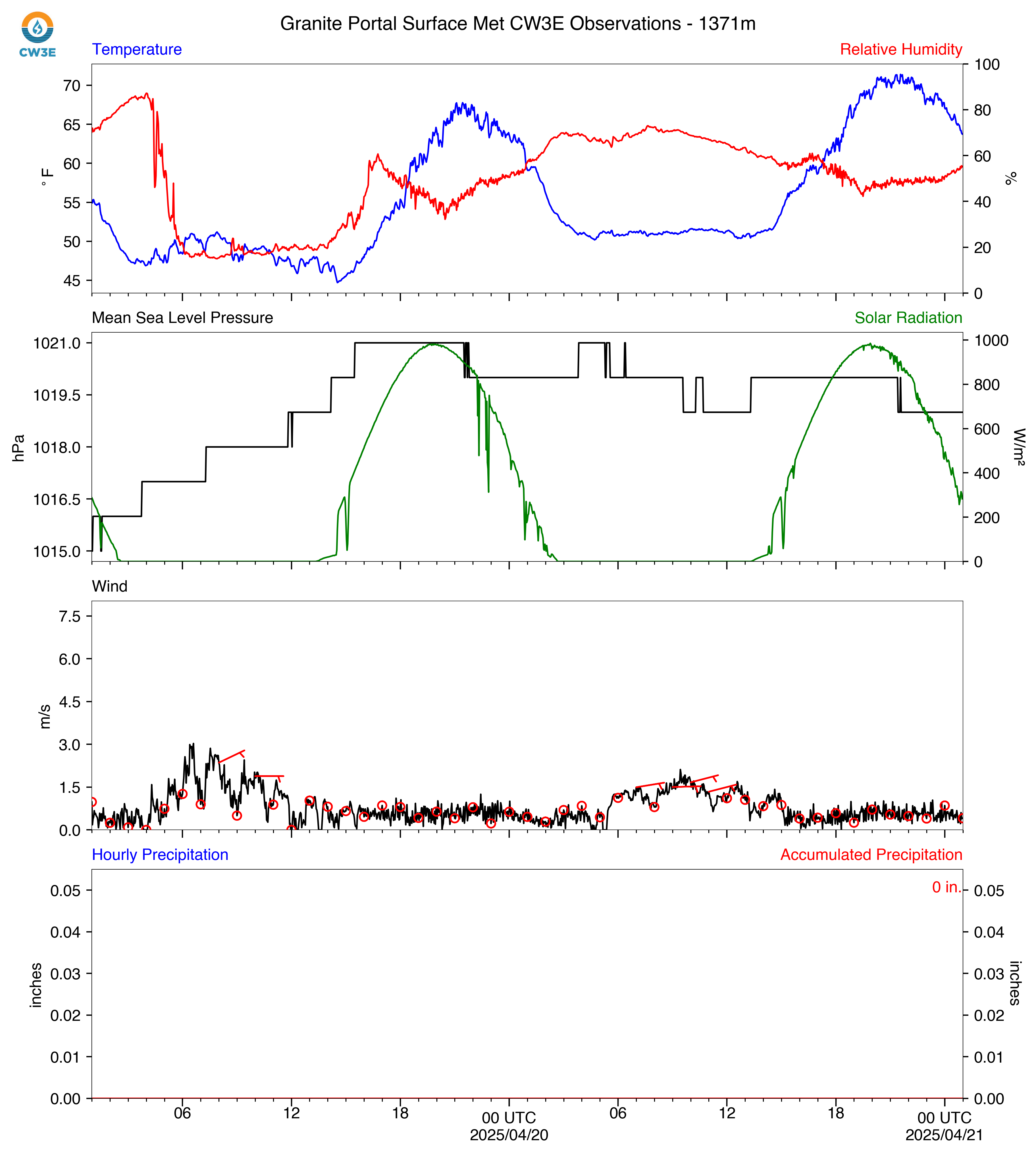
GPO_2025042100_SurfaceMet.png
2025-04-20 18:30
707K
GPO_2025030400_SurfaceMet.png
2025-03-03 17:22
709K
GPO_2025030800_SurfaceMet.png
2025-03-07 17:23
710K
GPO_2025041400_SurfaceMet.png
2025-04-13 18:29
711K
GPO_2025032500_SurfaceMet.png
2025-03-24 18:30
712K
GPO_2025042300_SurfaceMet.png
2025-04-22 18:33
712K
GPO_2025031400_SurfaceMet.png
2025-03-13 18:22
713K
GPO_2025030500_SurfaceMet.png
2025-03-04 17:22
716K
GPO_2025042700_SurfaceMet.png
2025-04-26 18:29
717K
GPO_2025041500_SurfaceMet.png
2025-04-14 18:29
719K
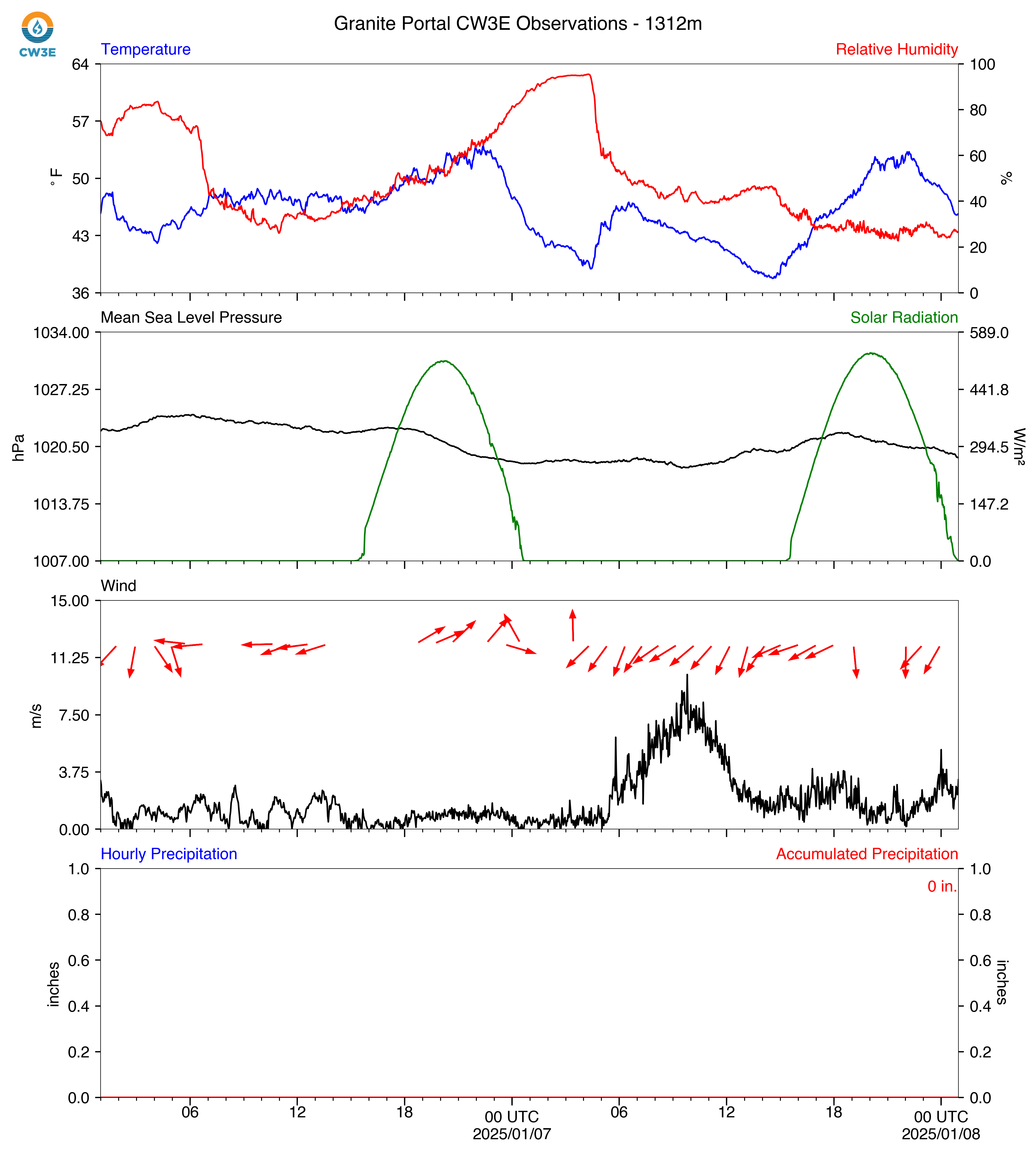
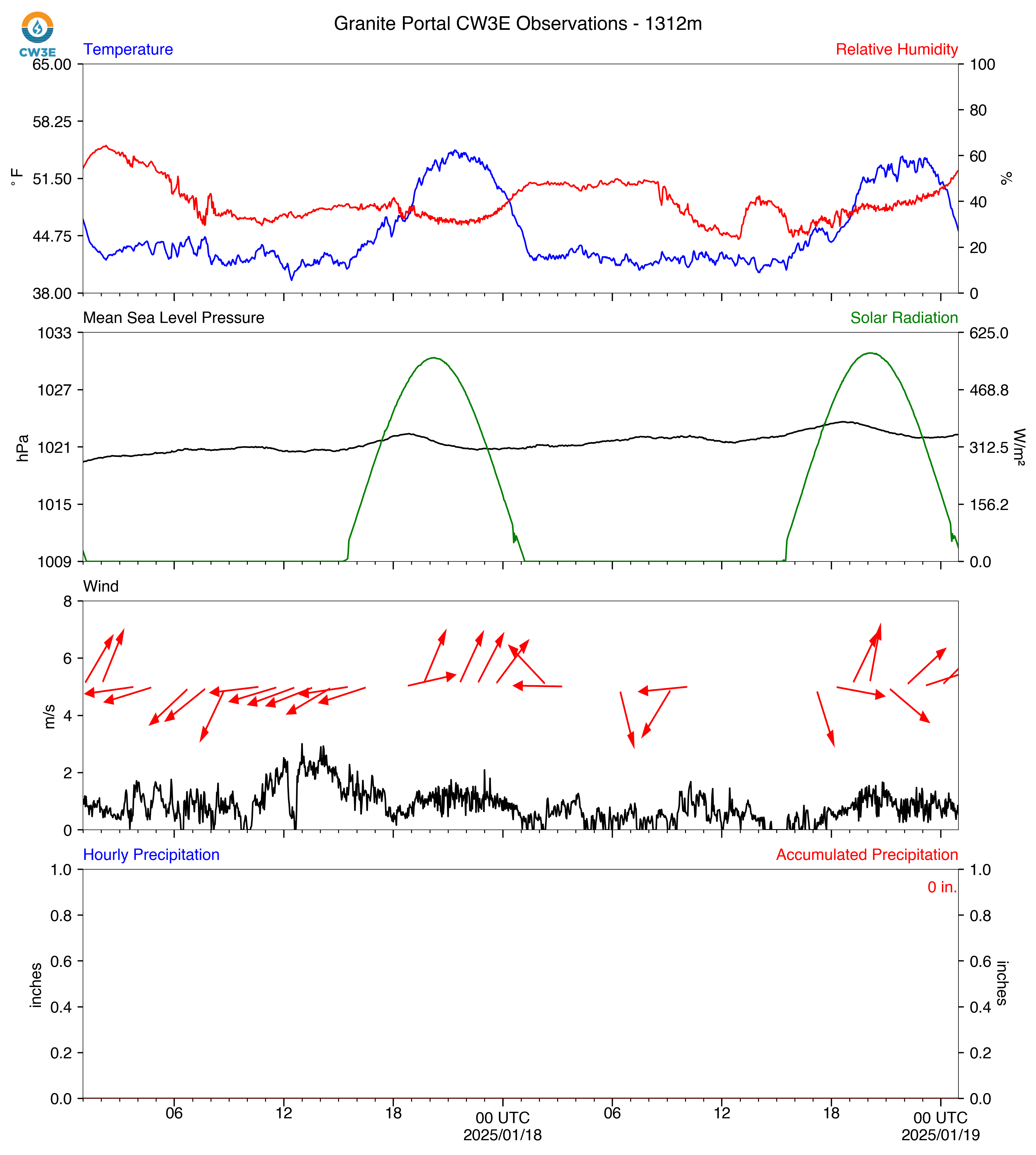
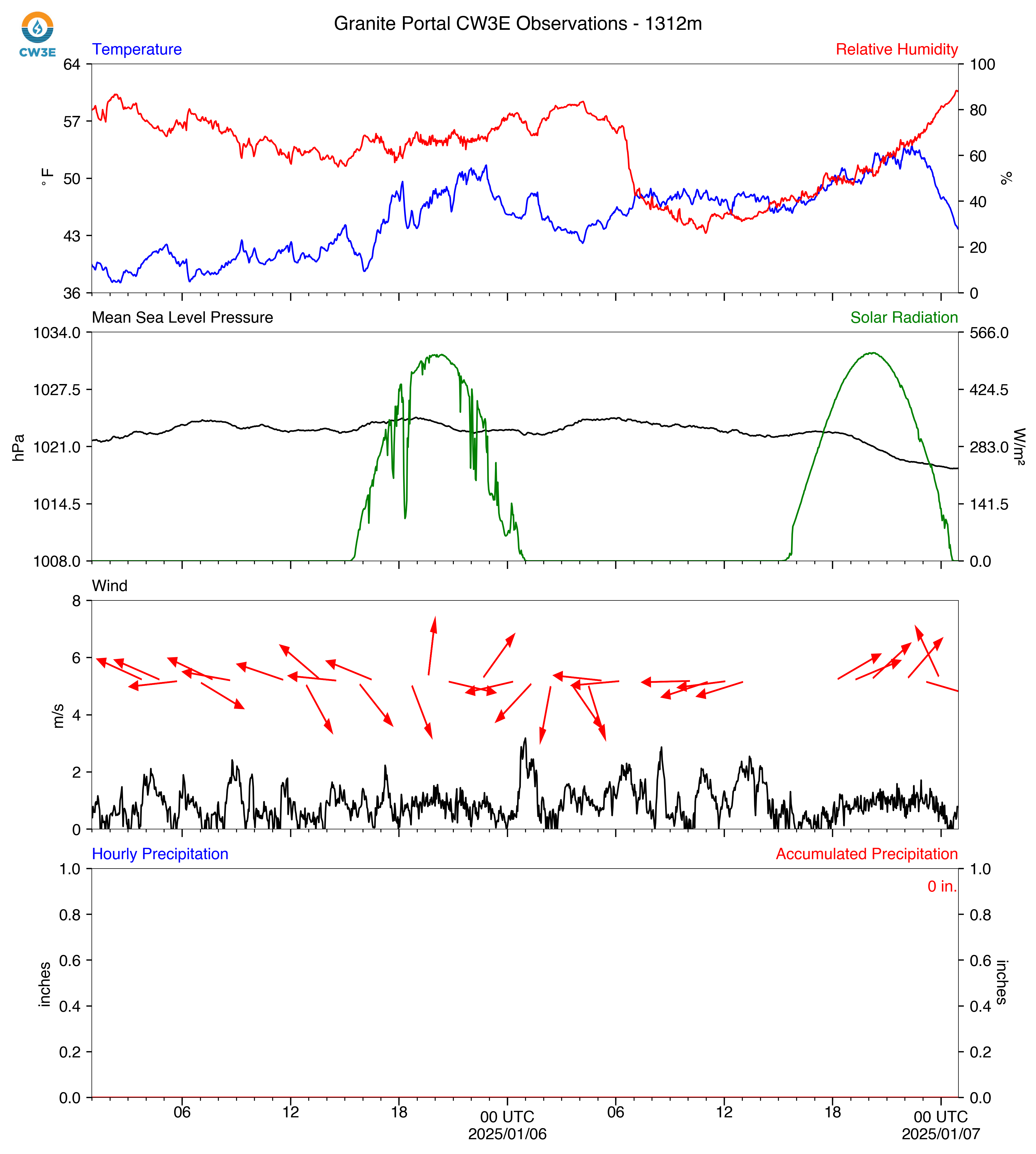
GPO_2025010800_SurfaceMet.png
2025-01-07 17:20
722K
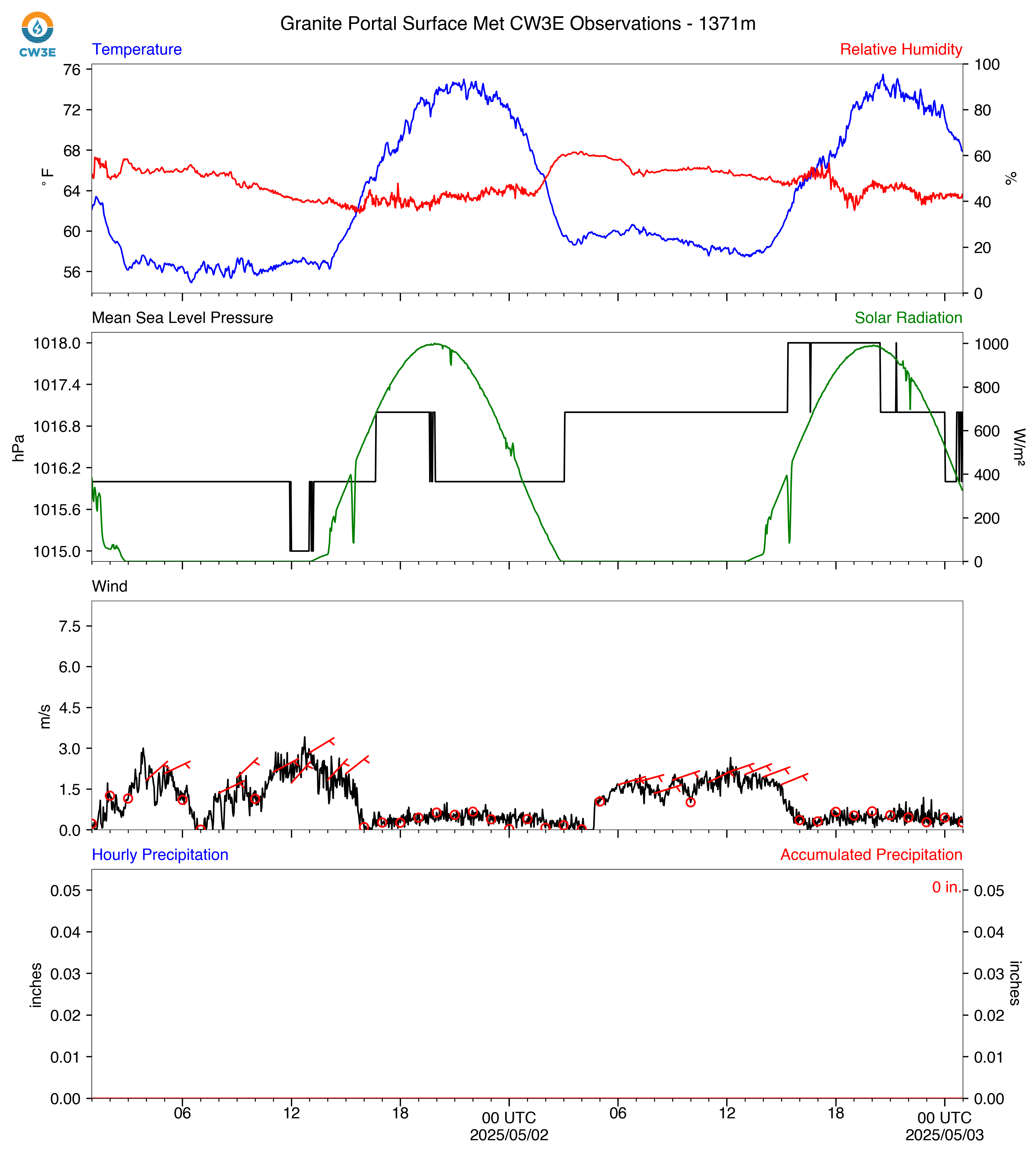
GPO_2025050300_SurfaceMet.png
2025-05-02 18:31
724K
GPO_2025031600_SurfaceMet.png
2025-03-15 18:21
724K
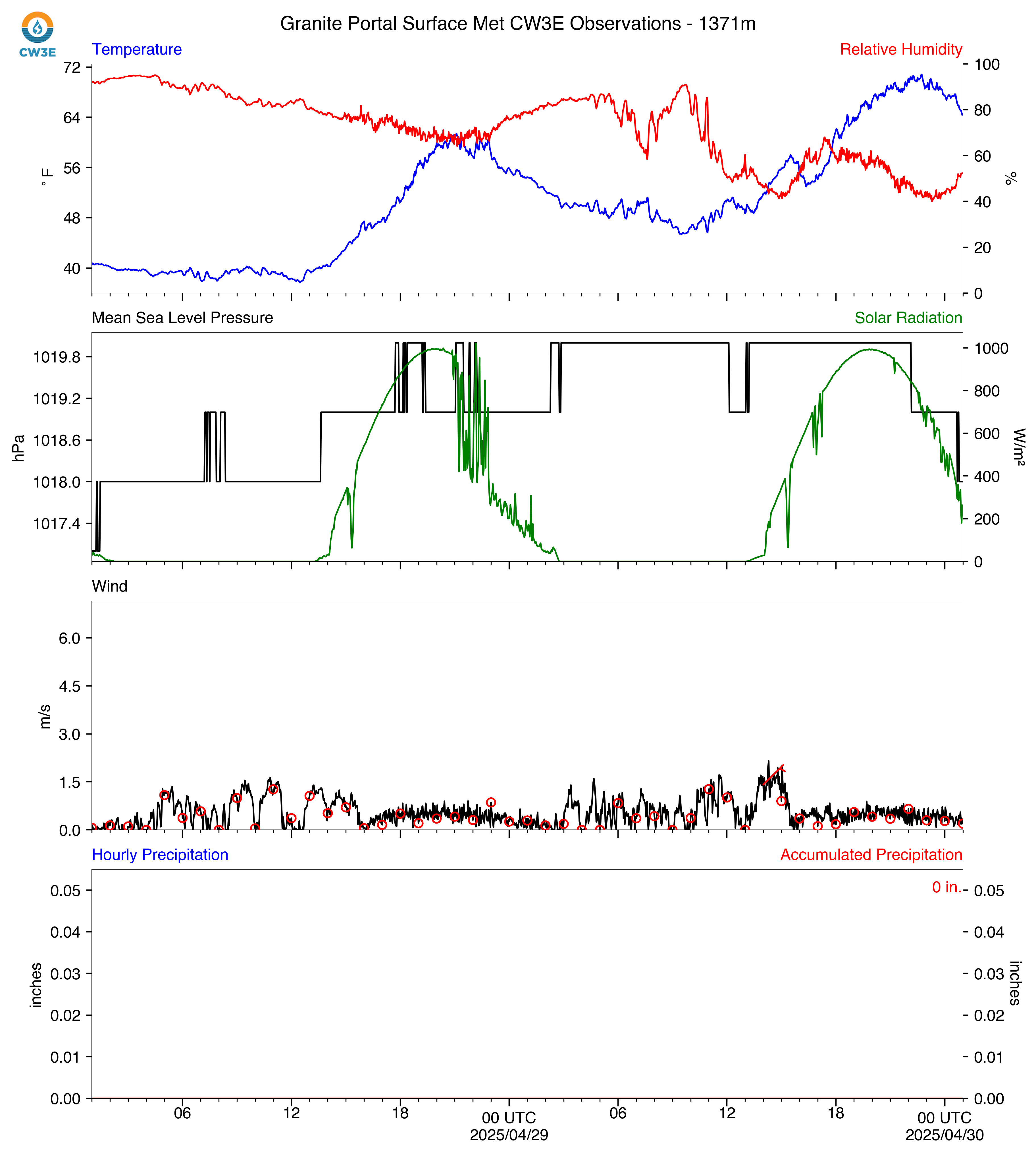
GPO_2025043000_SurfaceMet.png
2025-04-29 18:29
725K
GPO_2025040900_SurfaceMet.png
2025-04-08 18:28
725K
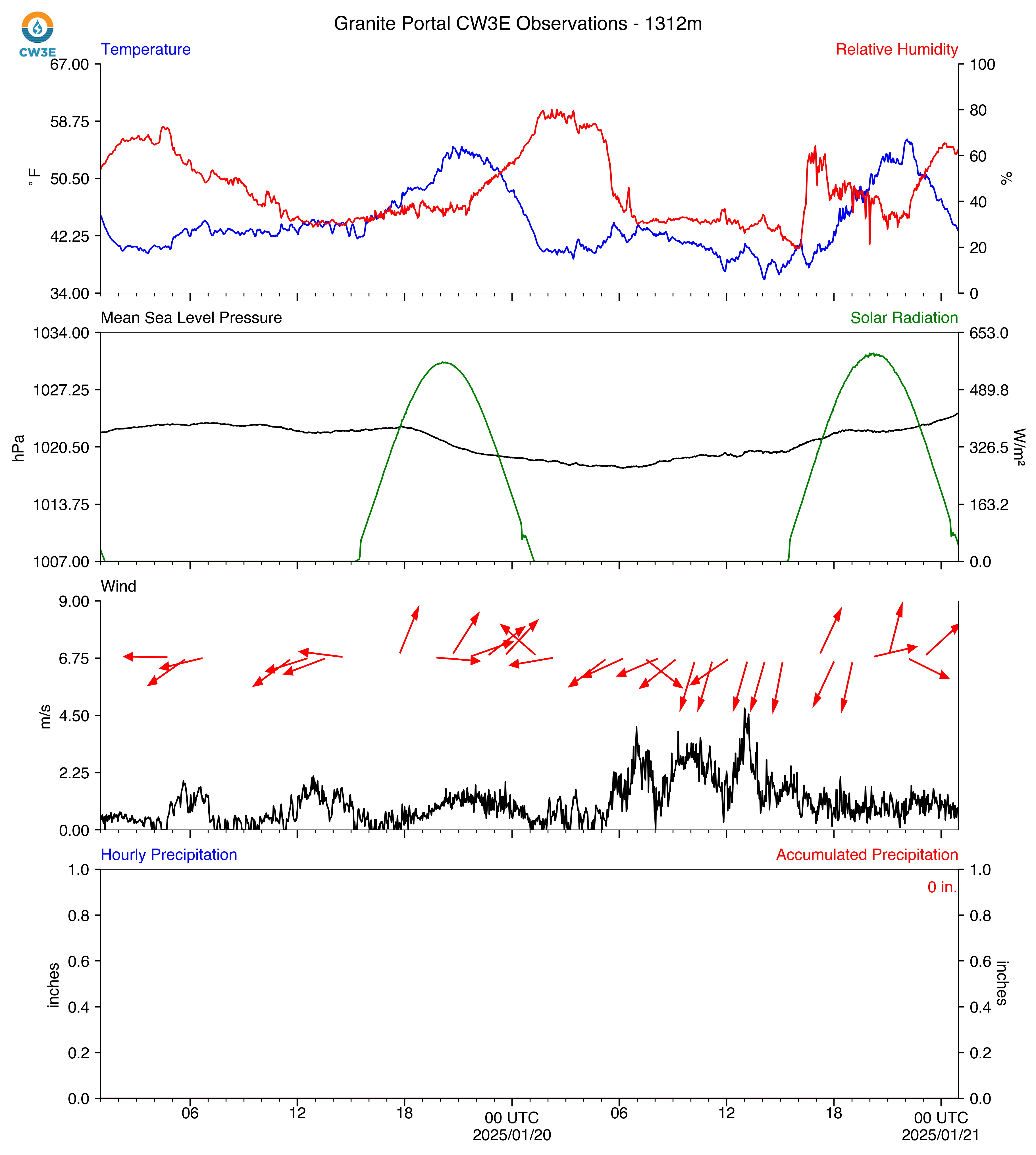
GPO_2025012000_SurfaceMet.png
2025-01-19 17:21
726K
GPO_2025042500_SurfaceMet.png
2025-04-24 18:30
727K
GPO_2025050200_SurfaceMet.png
2025-05-01 18:32
733K
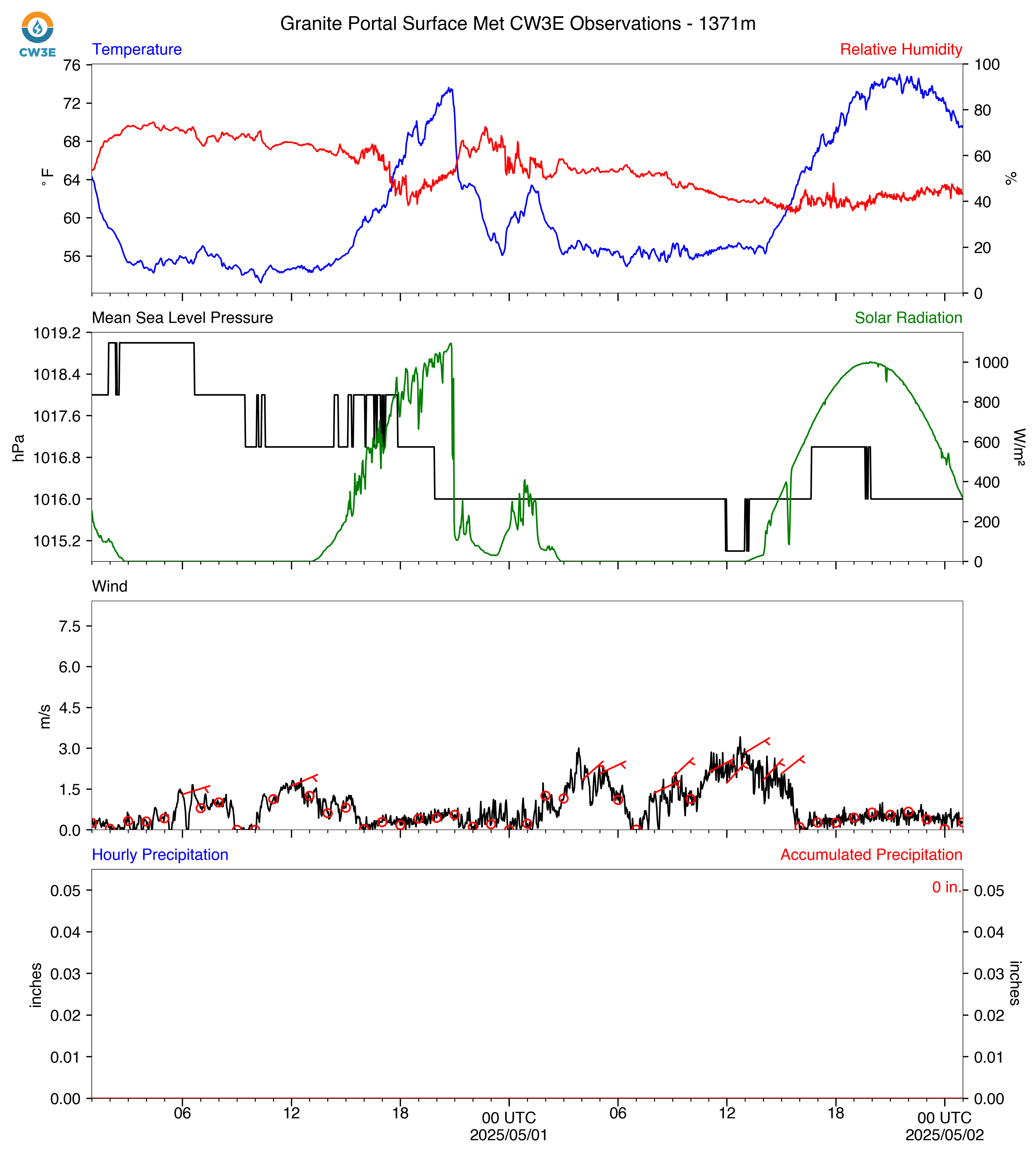
GPO_2025050100_SurfaceMet.png
2025-04-30 18:33
733K
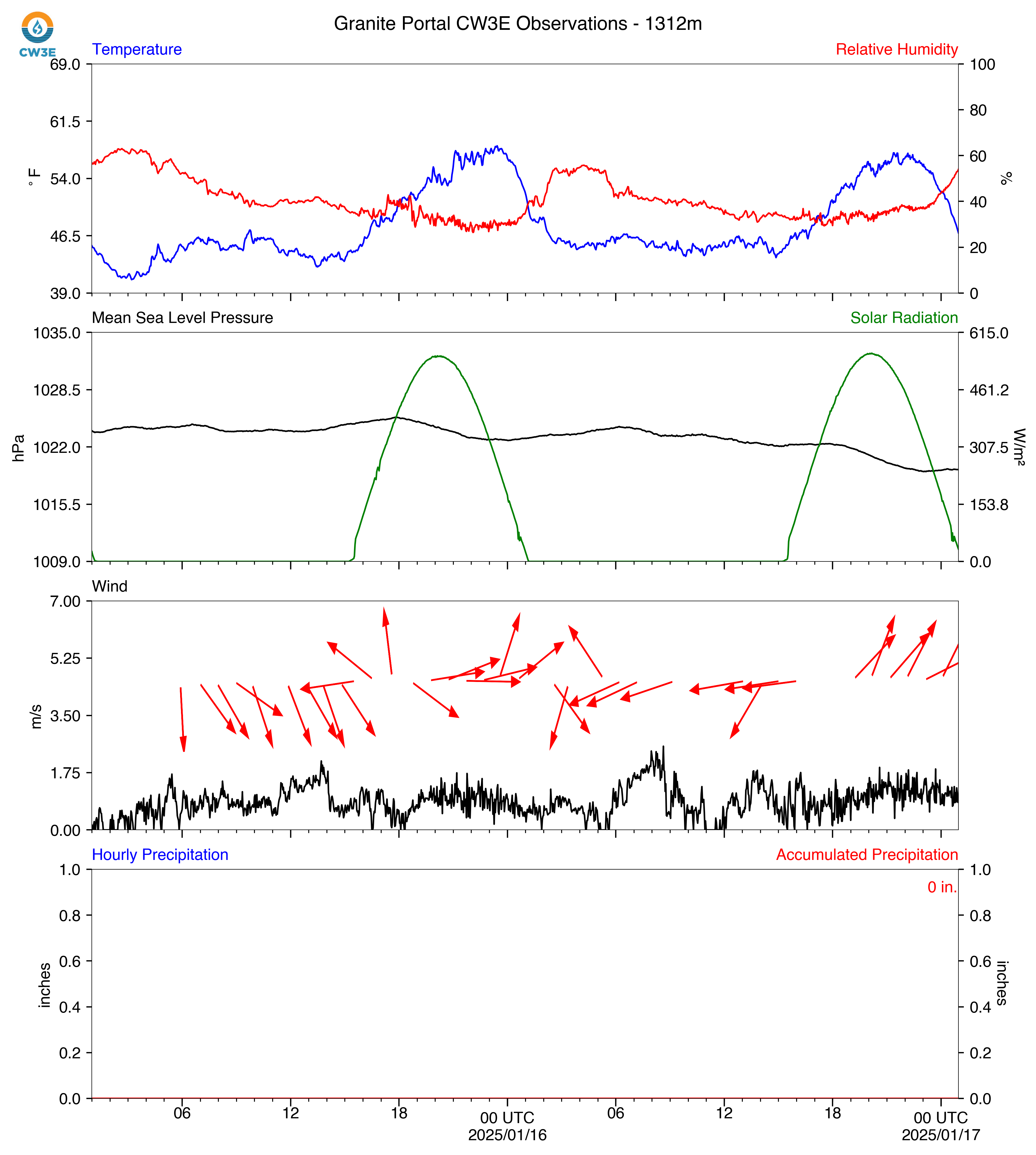
GPO_2025011900_SurfaceMet.png
2025-01-18 17:20
733K
GPO_2025032800_SurfaceMet.png
2025-03-27 18:31
733K
GPO_2025041100_SurfaceMet.png
2025-04-10 18:28
734K
GPO_2025031700_SurfaceMet.png
2025-03-16 18:21
735K
GPO_2025040600_SurfaceMet.png
2025-04-05 18:28
735K
GPO_2025012400_SurfaceMet.png
2025-01-23 17:22
736K
GPO_2025040400_SurfaceMet.png
2025-04-03 18:28
736K
GPO_2025042800_SurfaceMet.png
2025-04-27 18:29
736K
GPO_2025020300_SurfaceMet.png
2025-02-02 17:21
737K
GPO_2025011800_SurfaceMet.png
2025-01-17 17:20
739K
GPO_2025030600_SurfaceMet.png
2025-03-05 17:38
739K
GPO_2025012500_SurfaceMet.png
2025-01-24 17:20
739K
GPO_2025040800_SurfaceMet.png
2025-04-07 18:28
745K
GPO_2025040500_SurfaceMet.png
2025-04-04 18:27
746K
GPO_2025033000_SurfaceMet.png
2025-03-29 18:30
749K
GPO_2025021200_SurfaceMet.png
2025-02-11 17:26
750K
GPO_2025011600_SurfaceMet.png
2025-01-15 17:21
750K
GPO_2025012300_SurfaceMet.png
2025-01-22 17:21
750K
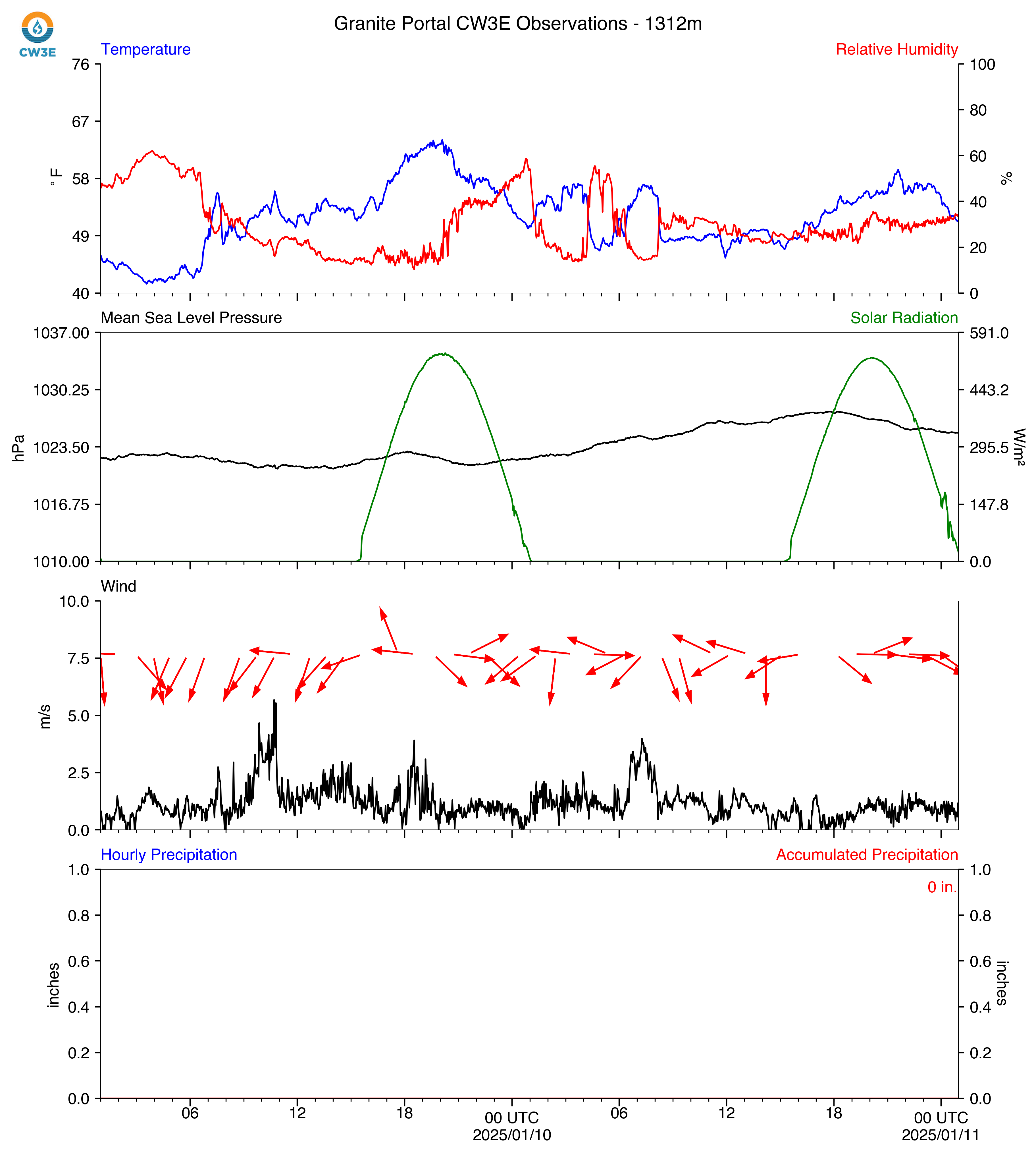
GPO_2025011200_SurfaceMet.png
2025-01-11 17:20
752K
GPO_2025041300_SurfaceMet.png
2025-04-12 18:28
753K
GPO_2025031300_SurfaceMet.png
2025-03-12 18:23
754K
GPO_2025041700_SurfaceMet.png
2025-04-16 18:29
755K
GPO_2025012100_SurfaceMet.png
2025-01-20 17:20
756K
GPO_2025011700_SurfaceMet.png
2025-01-16 17:20
757K
GPO_2025011100_SurfaceMet.png
2025-01-10 17:21
757K
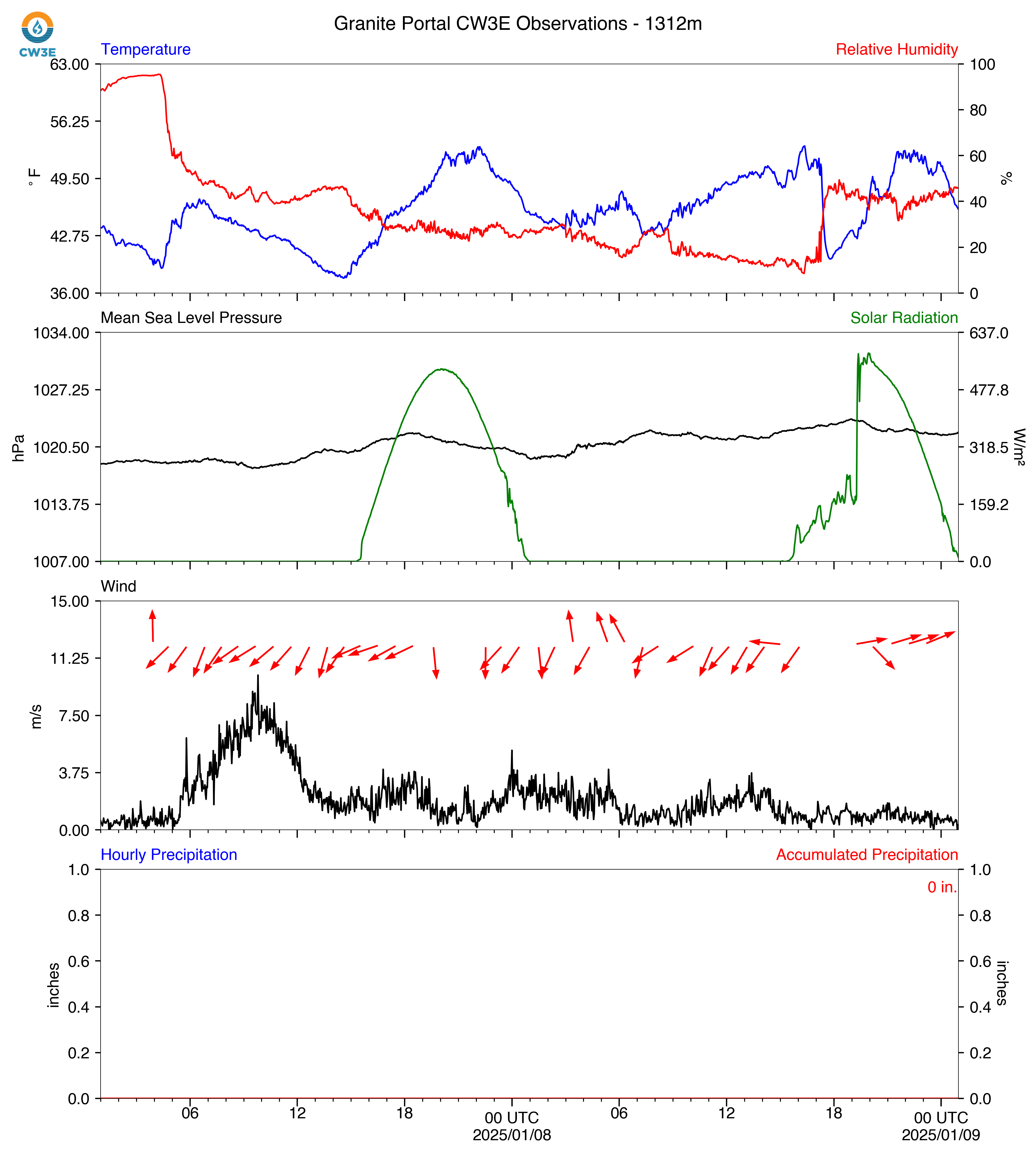
GPO_2025010900_SurfaceMet.png
2025-01-08 17:21
757K
GPO_2025012600_SurfaceMet.png
2025-01-25 17:20
759K
GPO_2025040700_SurfaceMet.png
2025-04-06 18:29
759K
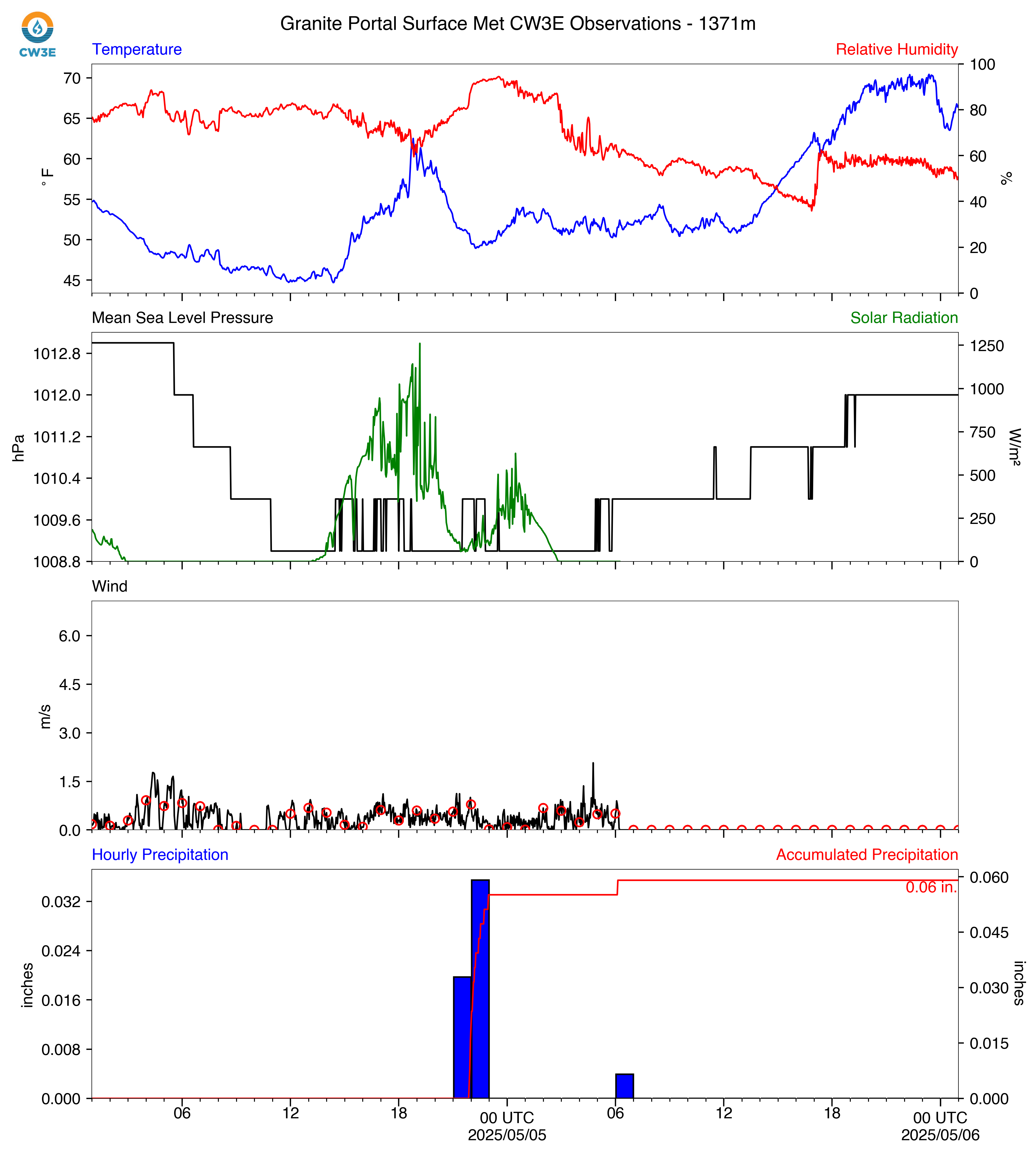
GPO_2025050500_SurfaceMet.png
2025-05-04 18:30
759K
GPO_2025011300_SurfaceMet.png
2025-01-12 17:33
760K
GPO_2025030300_SurfaceMet.png
2025-03-02 17:20
760K
GPO_2025021300_SurfaceMet.png
2025-02-12 17:25
762K
GPO_2025011400_SurfaceMet.png
2025-01-13 17:20
762K
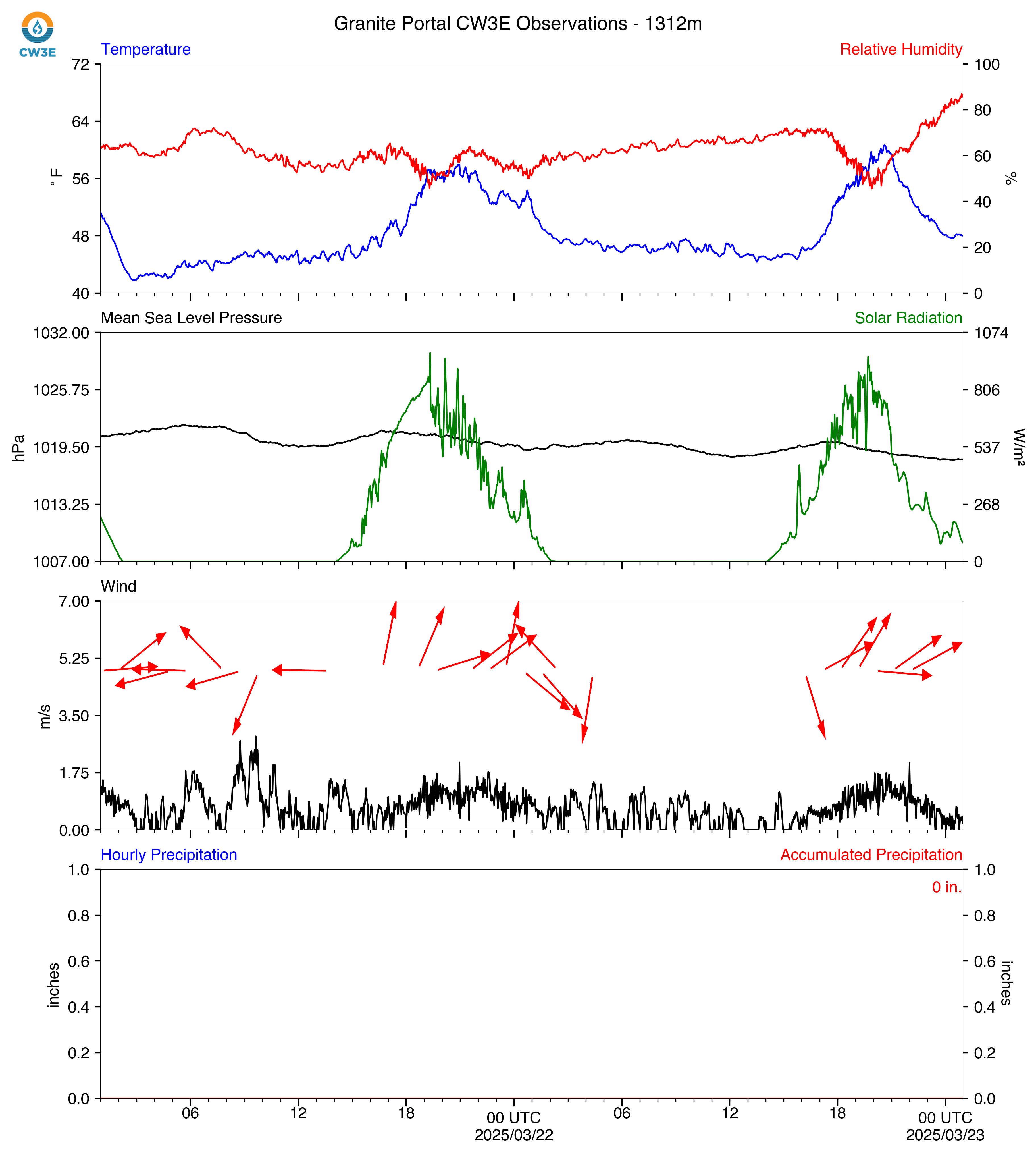
GPO_2025032400_SurfaceMet.png
2025-03-23 18:22
763K
GPO_2025030900_SurfaceMet.png
2025-03-08 17:20
763K
GPO_2025013100_SurfaceMet.png
2025-01-30 17:21
764K
GPO_2025031100_SurfaceMet.png
2025-03-10 18:22
765K
GPO_2025031900_SurfaceMet.png
2025-03-18 18:22
765K
GPO_2025040100_SurfaceMet.png
2025-03-31 18:31
765K
GPO_2025020100_SurfaceMet.png
2025-01-31 17:21
765K
GPO_2025041600_SurfaceMet.png
2025-04-15 18:29
765K
GPO_2025010700_SurfaceMet.png
2025-01-06 17:20
765K
GPO_2025022300_SurfaceMet.png
2025-02-22 17:20
767K
GPO_2025032300_SurfaceMet.png
2025-03-22 18:23
767K
GPO_2025031000_SurfaceMet.png
2025-03-09 18:19
768K
GPO_2025011500_SurfaceMet.png
2025-01-14 17:20
769K
GPO_2025022700_SurfaceMet.png
2025-02-26 17:20
770K
GPO_2025030200_SurfaceMet.png
2025-03-01 17:19
770K
GPO_2025033100_SurfaceMet.png
2025-03-30 18:30
771K
GPO_2025032900_SurfaceMet.png
2025-03-28 18:31
771K
GPO_2025012900_SurfaceMet.png
2025-01-28 17:21
772K
GPO_2025010100_SurfaceMet.png
2024-12-31 17:21
773K
GPO_2025011000_SurfaceMet.png
2025-01-09 17:20
776K
GPO_2025010400_SurfaceMet.png
2025-01-03 17:21
776K
GPO_2025013000_SurfaceMet.png
2025-01-29 17:21
777K
GPO_2025021000_SurfaceMet.png
2025-02-09 17:20
777K
GPO_2025041200_SurfaceMet.png
2025-04-11 18:28
777K
GPO_2025020900_SurfaceMet.png
2025-02-08 17:20
778K
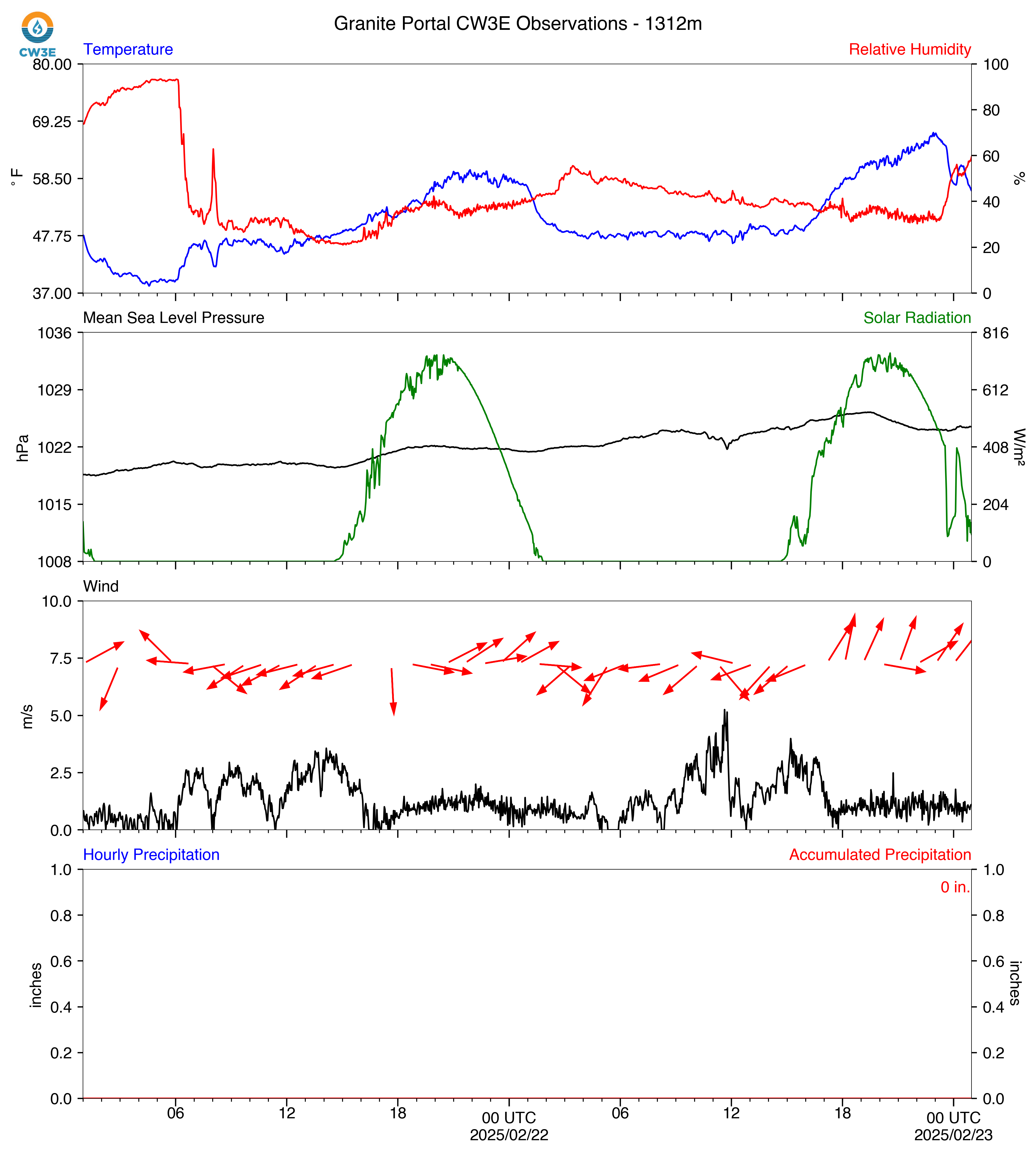
GPO_2025022400_SurfaceMet.png
2025-02-23 17:20
779K
GPO_2025021500_SurfaceMet.png
2025-02-14 17:21
781K
GPO_2025031200_SurfaceMet.png
2025-03-11 18:24
781K
GPO_2025021100_SurfaceMet.png
2025-02-10 17:26
781K
GPO_2025032000_SurfaceMet.png
2025-03-19 18:23
784K
GPO_2025010300_SurfaceMet.png
2025-01-02 17:22
784K
GPO_2025022800_SurfaceMet.png
2025-02-27 17:20
786K
GPO_2025020800_SurfaceMet.png
2025-02-07 17:21
786K
GPO_2025030100_SurfaceMet.png
2025-02-28 17:19
786K
GPO_2025022200_SurfaceMet.png
2025-02-21 17:20
786K
GPO_2025012800_SurfaceMet.png
2025-01-27 17:20
787K
GPO_2025022000_SurfaceMet.png
2025-02-19 17:21
788K
GPO_2025012700_SurfaceMet.png
2025-01-26 17:20
789K
GPO_2025012200_SurfaceMet.png
2025-01-21 17:21
789K
GPO_2025031800_SurfaceMet.png
2025-03-17 18:21
794K
GPO_2025021600_SurfaceMet.png
2025-02-15 17:20
794K
GPO_2025020400_SurfaceMet.png
2025-02-03 17:21
797K
GPO_2025010200_SurfaceMet.png
2025-01-01 17:21
798K
GPO_2025032100_SurfaceMet.png
2025-03-20 18:22
798K
GPO_2025022600_SurfaceMet.png
2025-02-25 17:21
798K
GPO_2025032200_SurfaceMet.png
2025-03-21 18:22
799K
GPO_2025021700_SurfaceMet.png
2025-02-16 17:21
799K
GPO_2025021900_SurfaceMet.png
2025-02-18 17:22
800K
GPO_2025010500_SurfaceMet.png
2025-01-04 17:20
800K
GPO_2025021400_SurfaceMet.png
2025-02-13 17:21
804K
GPO_2025020700_SurfaceMet.png
2025-02-06 17:21
806K
GPO_2025010600_SurfaceMet.png
2025-01-05 17:20
806K
GPO_2025020200_SurfaceMet.png
2025-02-01 17:23
806K
GPO_2025022500_SurfaceMet.png
2025-02-24 17:22
807K
GPO_2025022100_SurfaceMet.png
2025-02-20 17:19
813K
GPO_2025021800_SurfaceMet.png
2025-02-17 17:22
813K
GPO_2025020600_SurfaceMet.png
2025-02-05 17:21
820K
GPO_2025020500_SurfaceMet.png
2025-02-04 17:20
828K